Lets take a look at a few of the parameters we need for storm development.
300mb (Jet stream) Winds:
 The nose of the jet streak is rounding the trough and is shooting right in to southern Missouri. The above image depicts .
Surface Moisture (Dew Points):
 Dew points are often times a huge player in cool-season severe storms. A recent NWS study from the Paducah, Kentucky office has shown that the possibility of cool-season severe storms substantially increases when dew points rise above 48°. This model is indicating dew points over 50° Saturday night.
Instability:
 When looking at the instability it doesn't look that impressive. You can see a bulls eye of heightened CAPE over the region at 6am CT with values around 500 j/kg. Normally that wouldn't be too impressive. However, will cool-season storms, it has been found that instability isn't a huge player for severe storms to develop. To give some perspective, CAPEs will often times be over 3,000 - 4,000 j/kg (if not higher) in the summer.
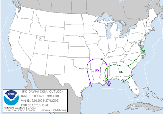
The Storm Prediction Center continues to indicate the best risk of severe weather is south of the area. I wouldn't be surprised if this area starts to slide further north over the next couple of days.

With a strong jet stream over the top of the region helping draw up moisture, it appears we could have some pretty hefty rainfall totals too. Here is the GFS' depiction of 24 hour rainfall totals ending 6am CT Sunday.
 The GFS is indicating over 1.5" of rain Saturday evening through Sunday morning.
At this point, it appears the best time for severe weather, if we see any, would be late Saturday night/early Sunday morning. That being said, we are still 110-120 hours away from this possibly happening. Lots of things could change between now and then. In fact, the storm hasn't even made its way onshore. As we have seen before, the models can and usually do change things up a little once they get better samples of data when the storm moves over land.
Bottom line. Stay tuned...
By the way, I am hoping that if we do see severe storms Saturday night they don't last too late. I've got to be up EARLY Sunday to catch a plane to a Digital Media conference so I don't need to have an all nighter. Mother Nature, if you are listening, please take that in to consideration. haha
No comments:
Post a Comment