Just a few more hours and it will be the start of fall... Meteorological Fall.I've been getting asked a lot the last couple of weeks, "When will fall get here?" It starts this Wednesday at midnight.Meteorologists break the year up in to four equal segments for the seasons.- Spring: March 1 - May 31
- Summer: June 1 - August 31
- Fall: September 1 - November 30
- Winter: December 1 - February 28 (or 29)
Even though your calendar might say fall starts September 23, if you are in the mood for fall to begin just wait another 51 hours.Which one of the season's is your favorite? Leave your answer in the comment section of the blog.
A nice morning and a warm afternoon...Take a look at lows from Sunday morning. Unfortunately, it is probably the last time you will be able to keep the windows open and the air conditioning turned off for a couple days. This afternoon we saw more heat and humidity. The combination of the two allowed for some cloud development and even a few showers and a thunderstorm in northwest Tennessee and western Kentucky.
 The interesting thing to note about today is that we tied a record today in Cape Girardeau, Missouri. The temperature spread from this morning to this afternoon was 37°. That ties the record maximum temperature range for this date set in 1967.
In the "John Like's Weird Statistics" category here's a tidbit from last week.Last Wednesday, Thursday, and Friday all go in to the books as below normal. Specifically speaking in Cape Girardeau, Missouri Wednesday was 4 degrees below normal, Thursday was 7 degrees below normal, and Friday was 5 degrees below normal.This marks the first time we have had three days below normal in a row since July 1-3, 2010. Actually, that stretch lasted for 5 days going back to late June.
We can say goodbye to the 2010 Heat Wave."See ya later. It wasn't that nice of a visit. Please don't come back anytime soon."A cold front passed through the area early this morning and behind the front much drier air is ushering in from our Canadian friends to the north.Remember the old commercial "How do you spell relief?" I spell it with L-O-W-E-R--D-E-W--P-O-I-N-T. Our dew point temperatures had been sitting in the 70's and at times lower 80's during the heat wave. As of 10am CT this morning, dew points are in the upper 50's to middle 60's with mid-50's dew points further upstream over northern Missouri and central Illinois.A taste of fall... In reality, temperatures won't be truly "fall-like" over the next couple of days, but compared to the middle 90's and above, this is going to feel like fall. High temperatures will most likely top out in the lower to middle 80's. Here is a look at forecast high temperatures (in red) and forecast dew point temperatures (in green) from one of the computer forecast models for Cape Girardeau, Missouri. (If you are new to the blog, read the information from right to left.)What's your favorite part about the cooler weather? (leave your answer in the comments) For me, it is the cooler nights. I can open up the windows and not need sponges to wipe the water off the walls.It looks like we are on our way back up to the 90's for the weekend, so make sure you get out and enjoy the cooler weather.
The 2010 Heat Wave is putting up some pretty staggering numbers...Here are a few statistics to look at.- 19 out of 20 days in August have been 90 degrees or higher at the Cape Girardeau Regional Airport. Cape Girardeau is running 4.2 degrees above normal per day.
- Poplar Bluff, Missouri has been 90 degrees or higher 24 days in a row and 36 out of last 38 days. For August, Poplar Bluff is 4.6 degrees above normal per day.
- 18 days this month have been 90 degrees or higher in Carbondale, Illinois. Carbondale is running 6.5 degrees above normal per day.
- 37 of the last 38 days have been 90 degrees or higher in Paducah, Kentucky. It has been 6.8 degrees above normal per day in August.
I am looking over weather data for the next week and it appears that we could see temperatures in the middle 80's by Wednesday. Keep your fingers crossed if you are tired of the heat.
We all know it has been hot, but just how hot? I was a little curious how this summer is holding up to summers over the last couple of years so I decided to pull up the numbers for Cape Girardeau, Mo, Carbondale, Il, Paducah, Ky, and Poplar Bluff, Mo.I took a look at "meteorological summer" which runs June 1 through August 31. To keep it fair, I looked at each meteorological summer from 2007-2010 and only went through August 8 of those years.2010 is going down as a hot one alright. Take a look at the statistics below.Data read as number of days hitting 90° or higher. (% of the days of summer, June 1 - August 8, hitting 90° or higher)Cape Girardeau, Mo:2010: 47 days of summer have been 90°+. (68%)2009: 20 days of summer were 90°+. (29%)2008: 33 days of summer were 90°+. (48%)2007: 34 days of summer were 90°+. (49%)Carbondale, Il:2010: 47 days of summer have been 90°+. (68%) 2009: 18 days of summer were 90°+. (26%) 2008: 24 days of summer were 90°+. (35%) 2007: 26 days of summer were 90°+. (38%)Paducah, Ky:2010: 46 days of summer have been 90°+. (67%) 2009: 20 days of summer were 90°+. (29%) 2008: 30 days of summer were 90°+. (43%) 2007: 33 days of summer were 90°+. (48%)Poplar Bluff, Mo:2010: 56 days of summer have been 90°+. (81%) 2009: 24 days of summer were 90°+. (34%) 2008: 31 days of summer were 90°+. (45%) 2007: 24 days of summer were 90°+. (35%)You can easily see that this year has seen more 90° than any other of the past four years. One thing to keep in mind, last summer (2009) was much cooler than normal. We had above normal rainfall which lead to much cooler temperatures in July.The data tells us that the average number of days 90°+ over the last four years is:Cape Girardeau, Mo: 33.5 daysCarbondale, Il: 28.8 daysPaducah, Ky: 32.3 daysPoplar Bluff, Mo: 33.8 daysThat means that the locations are xx% above the four year average:Cape Girardeau, Mo: 40%Carbondale, Il: 63%Paducah, Ky: 42%Poplar Bluff, Mo: 66%After looking at just that data, you could make the argument that Poplar Bluff, Missouri has been the "hottest" compared to four year normal of the four cities this summer.Keep in mind, this isn't taking in to consideration the actual high temperatures. This is just looking at the number of days 90° or higher. Paducah, Ky has had the hottest official temperature so far in the KFVS viewing area (104° on two occasions).
I probably don't need to say it. Its HOT! Overnight we didn't get much of a break as temperatures only dropped to the upper 70's and heat indices didn't drop below 80.At 10am CT, temperatures are ranging from 90 degrees in Cape Girardeau and Poplar Bluff to 95 degrees in Carbondale and Paducah. Factor the humidity in and heat indices are over 100.This kind of weather can be EXTREMELY dangerous. The city of Chicago had over 700 people killed during the 1995 heat wave.
We were able to get through yesterday without too many problems, but heat waves start to take their toll on the second day, third day, etc. As the heat continues to build and wear on our bodies over days and days that is when the problems start to arise. Please check on your neighbors and relatives and don't be afraid to call local agencies for help.Last night I mentioned the chance at slightly drier air moving in from the west. The drier air is still over southwest Missouri. With winds turning west/southwest we should begin to see the slightly drier air move in to parts of southeast Missouri. Unfortunately, the wind is going to stay between 3-10 mph. If it were a little faster, it could transport the air a little quicker. The drier air will allow for the humidity to drop and the heat index, or feels like temperature, to drop but it will also allow the air temperature to climb higher than yesterday.It still appears we will get a break from the excessive heat later this week and for the first half of the weekend. The heat will start to build back in Sunday and could be here through Wednesday. What kind of heat? Right now, it looks like we could be back in the upper 90's to lower 100's. Stay tuned...
What a day. The poor mercury in the thermometer must be tired from climbing sooo much. High temperatures climbed in to the upper 90°'s to lower 100°s. Notable was Paducah, Kentucky's 104° which tied Paducah's record high. It was previously set August 3, 1947.What is amazing about today's high temperatures is the fact we were able to hit numbers that high with the amount of humidity we had in the atmosphere. In an earlier post I mentioned that moist air doesn't like to get to high numbers like this. It usually doesn't, but it did today.Dew points at times today got as high as the lower 80°'s which is about as high as you will ever see them. The heat index at times was as high as 119°-123° in a few locations.All signs continue to point to a cold front moving towards the Heartland Wednesday. Ahead of the front, temperatures will climb another degree or two as compared to today. The reason? Compression of air as it slams in to the cold front.Models are also showing drier air moving in from the west. Dew points were only in the 60's across western Missouri and western Arkansas today. That is the air that should be moving in. I think it will make it in to southeast Missouri, but I am not confident in it moving across the Mississippi.
 Once the front passes, "cooler" air should move in taking high temperatures in to the upper 80° to around 90°.
Don't think we have turned the corner on the heat just yet. Data from the last three runs of the long range computer models are hinting at another round of temperatures in the upper 90°'s to 100°'s early next week. Stay tuned...
You know its going to be hot when the 10am temperature is already 91 degrees at the Cape Girardeau Regional Airport.10am temperatures around the region:- Blytheville: 95
- Carbondale: 90
- Dyersburg: 93
- Farmington: 88
- Harrisbug: 88
- Mt. Vernon: 86
- Paducah: 92
- Poplar Bluff: 90
- Sparta: 90
I knew that dew points were going to be higher than the forecast models were indicating (they almost always are), but I didn't expect them to be this high. As of 10am, dew points are ranging from 73 degrees in Harrisburg, Il to 82 in Poplar Bluff, Mo.The higher dew points, or moisture, is causing the heat index to jump in to the 100-111 degree range.
Just looking over the new forecast model data coming in tonight. It is still looking hot over the next couple of days.My forecast high temperatures for Tuesday:Illinois:- Carbondale: 98°
- Harrisburg: 97°
- Marion: 98°
- Metropolis: 98°
- Mt. Vernon: 99°
- Vienna: 97°
Kentucky:- Mayfield: 98°
- Murray: 98°
- Paducah: 98°
Missouri:- Cape Girardeau: 98°
- Charleston: 98°
- Dexter: 99°
- Farmington: 100°
- Jackson: 98°
- New Madrid: 99°
- Perryville: 99°
- Poplar Bluff: 99°
- Sikeston: 98°
- Van Buren: 100°
Tennessee:- Martin: 100°
- Tiptonville: 101°
- Union City: 100°
Wednesday should be the hottest day in the KFVS viewing area due to a cold front sliding south towards the area. Highs will most likely be in the lower 100°'s. Right now I have the forecast high for Cape Girardeau as 101°.Stay cool...
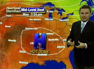
We haven't seen anything yet. All indications are pointing to the hottest air of the summer moving in to southeast Missouri, southern Illinois, western Kentucky, northwest Tennessee, and northeast Arkansas over the next 96 hours.Forecast models are advertising a mid-level high pressure area strengthening and moving over the Mid-Mississippi Valley region starting Monday. The mid-level high will be in place through Wednesday or Thursday. Typically when we have high pressure in place we have decent weather. Relatively clear skies due to sinking air from the high pressure. When you put high pressure up several thousand feet, when the air sinks it begins to compress. A study of physics shows that when you compress air, it heats up. That is what will be happening over the top of the KFVS viewing area.Now the big question, "How hot will it get?" That's a tricky one. We know that the air will have the capacity to heat but we are also going to have moderate amounts of moisture in the air (humidity).The more moisture air holds, the more difficult it is to heat. Good examples... Look at the desert and look at the Gulf Coast. The desert heats very quickly partially due to the lack of moisture in the air. Along the Gulf Coast it gets hot, but rarely do you see it get extremely hot. That is mostly due to the amount of moisture in the air.Models are suggesting dew points in the lower 70's over the next several days. That is a drop compared to where we have been over recent weeks. However, the forecast models have been forecasting dew points too low. It wouldn't surprise me if we've got dew points in the middle 70's if not a little higher. This should keep our temperatures from jumping through the roof.Here is a look at air temperatures from various forecast models. There is a legend to the right of each of the meteograms. In the legend you will see there are two different forecast models being depicted. The GFS and the NAM. The last two runs of the models, 0z (7pm) and the 6z (1am), are shown.Cape Girardeau:
 Farmington, Mo:
 Paducah, Ky:
 Jonesboro, Ar:
 Before you ask (you always do), these are the only sites available with data displayed in the fashion in the KFVS viewing area. Use the locations from above to extrapolate your location.As of now, I don't think we will hit the 100 degree mark. It is very difficult for us to hit 100 degrees around here. I am speaking specifically for Cape Girardeau. I wouldn't be surprised to see Farmington, Mo hit 100 or the Missouri bootheel hit 100 at some point over the next couple of days.By the way, the last time Cape Girardeau officially hit 100 degrees was August 24, 2007. Will we hit the century mark again?
Today marks the first day of the last month of "meteorological summer". We can finally see some light at the end of the tunnel!Let's take a look back at July 2010...Surprisingly, the month turned out to not be as hot for some areas.Temperature departure from normal:- Cape Girardeau, Mo +1.9 degrees per day
- Carbondale, Il +4.4 degrees per day
- Paducah, Ky +3.5 degrees per day
- Poplar Bluff, Mo +1.4 degrees per day
Hottest day of the month:- Cape Girardeau, Mo 96 on July 6
- Carbondale, Il 96 on July 23 and 24
- Paducah, Ky 98 on July 24
- Poplar Bluff, Mo 97 on July 29
You get the idea from the data above that it has been a bit hotter in southern Illinois and western Kentucky. Keep in mind, the thermometer might not have read higher, but it was hotter as compared to what the normal temperature should be.The main culprit for it feeling so hot last month was the humidity. When I am talking about humidity, I am referring to the amount of moisture in the air. The best measure and indicator as to the humidity is the dew point temperature. In basic terms the dew point is the measure of the amount of moisture in the air. (Go here for a full definition of dew point.)As I often say on the television, dew points above 60 degrees starts to make it feel uncomfortable outside. Dew points over 70 degrees makes it feel tropical/very uncomfortable. Dew points through the month of July have been sitting in the middle to upper 70's. That is very humid air. Typically in late July and August we will see dew points in the mid-70's. A couple days I saw the dew point hit 80 degrees which is about as high as you will see. (A few times during the summer you can find dew points in the lower 80's in Iowa over the corn fields.)The dew point is used with the air temperature to calculate the heat index, or the "feels like" temperature. The heat index seems to have been sitting in the lower 100's throughout much of the month. I think the highest I saw it get was around 113 (in Mt. Vernon, Il).So has it been a hot month? Generally speaking.... A little. Has it felt hot? ABSOLUTELY!July also turned out to be relatively dry. If I had a nickel for every time someone has told me, "It hasn't rained here all summer. It will rain two blocks from my house, but not at mine. Bring me some rain." I could be sitting on a beach sipping drinks with no worries.Let's take a look at July's rainfall numbers.Precipitation departure from normal:- Carbondale, Il -1.85"
- Paducah, Ky -3.09"
- Poplar Bluff, Mo +0.40"
As you can see, it again depends on where you live. Some areas have been around normal and others have been well below normal.It is interesting to compare the precipitation departure from normal to the temperature departure from normal. Notice that the areas that are well below normal for rainfall are the areas that are quite a bit above normal for temperature. This is not abnormal. In fact, it is to be expected.