Friday, April 30, 2010
Live Streaming Storm Coverage
I will be giving live streaming coverage of the storms tonight as they move through the KFVS viewing area. I'm doing this from home so forgive the lack of video quality.
7:15pm Weather Update
A line of storms is continuing to track across the state of Missouri. Tornado watches blanket the state. There have been a few reports of tornadoes over the southern part of the state near Gainesville, Missouri. We are probably 1-2 hours from it beginning to affect parts of the KFVS viewing area.

I wanted to show you a different look at the line that is moving over the southern part of the state. This is a 3-dimensional look at the line.

If you click on the image you can see different sections I pointed out. For instance, from your vantage point you are looking to the west and "in to the line". To the right of the image is the Northeast. To the left is the Southwest.
The storm that currently has a tornado warning and has had a history of producing a tornado (and damage) is pointed out.
Also note the heights of the storms. The white horizontal lines indicate 10,000 feet. A few of the storms in the line are over 40,000'. The storm that has the tornado warning is topping out a little over 47,000'.
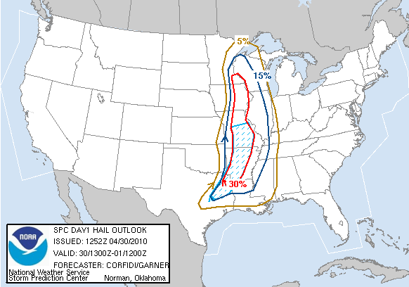
3pm Weather Update: Moderate Risk Expanded
The Storm Prediction Center has put out their 3pm update to the Day 1 Outlook. They have expanded the "Moderate Risk" area to cover more of Missouri.

The outlook covers from now until 7am CT Saturday morning.
Here is a look at the specific weather type probabilities.
Tornado:

Hail:

Wind:

The blue "hatched" area under the tornado probability indicates where there is a 10% or greater probability of a tornado EF2-EF5 withing 25 miles of any given point.
A tornado watch is already in effect for the northwestern portion of the KFVS viewing area. I expect other portions of at least southeast Missouri to be placed under a watch before the night is over. This will be a good night to make sure your NOAA Weather Radio is turned on before you go to sleep.
Tornado Watch #115
The Storm Prediction Center has issued Tornado Watch #115. The watch is in effect until 10:00pm CT Friday night.

A watch means that conditions are favorable for the development of thunderstorms capable of producing 1"+ diameter hail, damaging wind, and tornadoes.
Storms in the watch area could produce hail up to 2.5" in diameter. Wind gusts over 74mph will be possible from thunderstorms. Storms are expected to move to the northeast at 50mph.
11:40am Weather Update
The Storm Prediction Center just issued their new Day 1 Outlook and it now includes parts of southeast Missouri in a "Moderate Risk" for severe weather through 7am Saturday.
 In reading their discussion, there is some concern about the possibility of tornado development in northern Arkansas and southeast Missouri. The potential exists for a strong tornado in that area.
Here are the probabilities with the new outlook.
Tornado:

Hail:

Wind:

I am debating on going out chasing later today. All of the cloud cover around the area concerns me. Clouds usually don't allow the atmosphere to destabilize. However, I can see some of the instability indices that we look at starting to increase over south central Missouri. If I do go chasing, I'll try to put some live streaming video up here on the blog so you can go with me.
Storms Tonight Through Weekend
The weather is going to be active for the next 72 hours or more. It looks like there will be chances for severe weather and heavy rain.
First lets talk about the thing that looks pretty sure. Heavy rain. We are going to have a front that stalls out around the central United States. This is going to allow for moisture to stream up from the Gulf of Mexico. As the moisture encounters the front it will be lifted and become rain.
Here is a look at this morning's 12z (7am) run of the NAM forecast model. The below graphic shows accumulated precipitation for the 72 hour period starting this morning at 7am and ending at 7am Monday morning.

The model is showing anywhere from 1" to as much as 9" of rain across the Ohio River Valley. A few specific amounts from the NAM model. (Click the images to see a larger version.)
Now lets talk thunderstorms. The Storm Prediction Center (SPC) has parts of the KFVS viewing area highlighted in their severe weather outlook for today through Sunday morning.
Here is a look at SPC's Day 1 Outlook. This outlook covers from now until 7am Satuday.

Tornado Probabilities:

Hail Probabilities:

Wind Probabilities:

SPC continues the "Slight Risk" for severe weather in their Day 2 Outlook. This covers from 7am Saturday through 7am Sunday.

Reminder: KFVS12 and the Heartland StormTeam has a new way for you to be alerted to severe weather watches and warnings. If you are on Facebook, become a "fan" or "like" KFVS Weather Alerts. Watches and warnings will appear in your news feed. On Twitter you can follow @kfvsweather and watches and warnings will be tweeted. Both services are offered free of charge.
First lets talk about the thing that looks pretty sure. Heavy rain. We are going to have a front that stalls out around the central United States. This is going to allow for moisture to stream up from the Gulf of Mexico. As the moisture encounters the front it will be lifted and become rain.
Here is a look at this morning's 12z (7am) run of the NAM forecast model. The below graphic shows accumulated precipitation for the 72 hour period starting this morning at 7am and ending at 7am Monday morning.

The model is showing anywhere from 1" to as much as 9" of rain across the Ohio River Valley. A few specific amounts from the NAM model. (Click the images to see a larger version.)
- Cape Girardeau, Mo: 3.49"
- Farmington, Mo: 1.22"
- Paducah, Ky: 3.35"
Now lets talk thunderstorms. The Storm Prediction Center (SPC) has parts of the KFVS viewing area highlighted in their severe weather outlook for today through Sunday morning.
Here is a look at SPC's Day 1 Outlook. This outlook covers from now until 7am Satuday.

Tornado Probabilities:

Hail Probabilities:
Wind Probabilities:

SPC continues the "Slight Risk" for severe weather in their Day 2 Outlook. This covers from 7am Saturday through 7am Sunday.

Reminder: KFVS12 and the Heartland StormTeam has a new way for you to be alerted to severe weather watches and warnings. If you are on Facebook, become a "fan" or "like" KFVS Weather Alerts. Watches and warnings will appear in your news feed. On Twitter you can follow @kfvsweather and watches and warnings will be tweeted. Both services are offered free of charge.
Wednesday, April 28, 2010
Another Round of Storms
It looks like we are headed towards an active weather pattern. A upper-level low is going to stall out over the southwest United States and will send pieces of energy our way to help spark showers and thunderstorms along a stalled out front that will reside over the Midwest.
The Storm Prediction Center is highlighting portions of the country for severe weather in their Day 3 Outlook.

The above outlook covers the time period from 7am Friday through 7am Saturday.
The SPC is also highlighting an area where there could be severe weather in their extended outlooks.

Specifically the above graphic is pointing out areas that could see severe weather Saturday.
Saturday, April 24, 2010
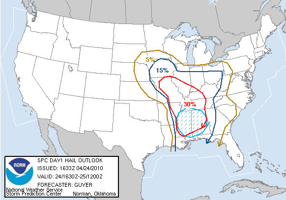
11:45am Weather Update
The Storm Prediction Center has put out their new Day 1 Outlook. This covers from now until 7am Sunday.

All of western Kentucky and northwest Tennessee and parts of southeast Missouri and southern Illinois are included in the "High Risk" area. The remainder of the KFVS viewing area is under a "Moderate Risk" area.
Here is the Tornado probabilistic outlook:

Here is the Hail probabilistic outlook:

Here is the Damaging Wind probabilistic outlook:

Everyone should be on their toes today keeping an eye to the sky. Take a minute right now to think about what you are going to do/where you are going to go if a Tornado Warning is issued for your location.
All of western Kentucky and northwest Tennessee and parts of southeast Missouri and southern Illinois are included in the "High Risk" area. The remainder of the KFVS viewing area is under a "Moderate Risk" area.
Here is the Tornado probabilistic outlook:

Here is the Hail probabilistic outlook:
Here is the Damaging Wind probabilistic outlook:

Everyone should be on their toes today keeping an eye to the sky. Take a minute right now to think about what you are going to do/where you are going to go if a Tornado Warning is issued for your location.
Tornado Watch #94
The Storm Prediction Center has issued Tornado Watch #94. The watch is in effect until 8:00pm CT Saturday night.
I will be heading in to work soon.

I will be heading in to work soon.
Active Day
Just a quick post to let you see the latest on today's weather situation.
The Storm Prediction Center has more of the KFVS viewing in their "Moderate Risk" area for severe weather today.

A Tornado Watch is likely to be issued in the next couple of hours for parts of southeast Missouri, southern Illinois, and western Kentucky.
The Storm Prediction Center has more of the KFVS viewing in their "Moderate Risk" area for severe weather today.

A Tornado Watch is likely to be issued in the next couple of hours for parts of southeast Missouri, southern Illinois, and western Kentucky.
Friday, April 23, 2010
Tornado Watch #80
The National Weather Service in Memphis, TN has expanded Tornado Watch #80 to include Dunklin and Pemiscot counties in southeast Missouri and Clay County, Arkansas. The watch is in effect until 8pm CT Friday.

Storms that currently have Severe Thunderstorm Warnings are moving through central Arkansas. At current speed and direction the storms should start to move in to southwestern portions of the KFVS viewing area around 6pm CT.

Storms that currently have Severe Thunderstorm Warnings are moving through central Arkansas. At current speed and direction the storms should start to move in to southwestern portions of the KFVS viewing area around 6pm CT.
1:00pm Weather Update
Tornado Watches are draped over Arkansas, Tennessee, Louisiana, and Mississippi this afternoon. That area will be under a Tornado Watch until 8pm CT this evening.
The Storm Prediction Center has put out their latest Day 2 Outlook and they have included more parts of the KFVS viewing area under the "Moderate Risk" area for severe thunderstorms from 7am CT Saturday through 7am CT Sunday.

The "Moderate Risk" area now includes parts of southeast Missouri, southern Illinois, all of western Kentucky, and northwest Tennessee.
To go along with the outlook, here is the probability chart by the Storm Prediction Center for tomorrow.

The probability chart shows the percent chance of severe weather occurring anywhere within a given point inside the area. The blue hatched area means that there is at least a 10% chance of significant severe weather occurring.
I am getting a little concerned about tomorrow afternoon. Specifically from 1pm-8pm. If this morning's run of the GFS is correct, it could get "interesting" especially in western Kentucky and northwest Tennessee.
8:00am Storm Update
It appears likely that an outbreak or two of severe weather will happen over the next 36-45 hours for parts of the country.
There is a lot of data to go over so this will be somewhat short and to the point. There is still a chance for strong to severe storms around southeast Missouri, southern Illinois, western Kentucky, northwest Tennessee, and northeast Arkansas today through Saturday.
Here is the latest from the Storm Prediction Center (SPC). This covers now through 7am CT Saturday.

Southeast Missouri and southern Illinois are included in the "Slight Risk" area. Northeast Arkansas and parts of the Missouri bootheel are included in the "Moderate Risk" area.
Tornado Probabilities*:

Hail Probabilities*:

Damaging Wind Probabilities*:

*Probabilities indicate the percentage that any given point in the area will see that type of weather. It doesn't mean there is a xx% chance of that weather for the entire area.
Here is a look at the severe weather outlook from SPC for Saturday. The outlook covers from 7am CT Saturday through 7am CT Sunday.

Here is a look at the overall probabilities of severe weather.

My thoughts are still pretty much what I said two posts ago (see below).
- First, we will see the possibility of thunderstorms developing along a warm front passes through the area (southwest to northeast) today. However, most of the storms should fire once the front is north of the area. The main threat from these storms would be large hail.
- Decaying storms will move in to the area overnight tonight/early Saturday morning (before sunrise). This line will come from a line of storms from western Missouri/northeast Akansas (if they develop). The main threat from these storms would be damaging wind.
- Thunderstorms will "pop"/initiate over the top of us Saturday. This could start as early as late Saturday morning. As a surface low develops over the top of the KFVS viewing area, there will be a threat for tornadoes on the east side of the low. This would be mainly confined to Tennessee and Kentucky. The main threat with these storms would be large hail, damaging wind, and tornadoes (east of Mississippi).
Thursday, April 22, 2010
Weekend Storm Update
The Storm Prediction Center is keeping parts of the KFVS viewing area in the "Slight Risk" area for Friday and Saturday.
Here is the Day 2 Outlook. This covers 7am CT Friday through 7am Saturday.

Here is a look at the probabilities product put out by SPC for the same time frame.

Finally, here is a look at the Day 3 Outlook. This covers 7am CT Saturday through 7am Sunday.

My thoughts haven't changed too much from my previous blog post. However, one thing I have noticed in the models is a lack of instability for Saturday. This could be a situation where storms develop along the Gulf Coast states rob some of our instability and could hinder big storms from developing. This doesn't mean that storms won't fire Saturday, but they might not be as bad.
I would still keep an eye on the weather Friday through Saturday.
Wednesday, April 21, 2010
Storms Later This Week
Heads up everyone. It looks more and more like we will see a chance for severe storms later this week.
A storm is moving in to the southwest United States today. This storm will move east across the country. Once it reaches the Plains, ingredients will come together to spark storms in Kansas, Oklahoma, and Texas.
By Friday, the storm will have moved east enough to start to get some activity around southeast Missouri, southern Illinois, western Kentucky, northwest Tennessee and northeast Arkansas.
Here is the Day 3 Outlook from the Storm Prediction Center. The outlook covers the time period from 7am CT Friday - 7am CT Saturday.

A warm front should begin to lift north across the area Friday afternoon. Thunderstorms will pop along the front. That is my biggest concern around the region Friday. Eventually the front should move up to north of St. Louis. Along the warm front the main threat will be large hail and possibly a few tornadoes.
Further west, more organized lines of storms will develop and move east. Some of these storms could impact the KFVS viewing area late Friday night through early Saturday morning.
SPC has included parts of the region in their Day 4 "heads up". (They don't start putting out Outlook products until day 3.) This covers 7am CT Saturday - 7am CT Sunday.

All three main severe weather types (damaging wind, hail, and tornado) is possible at this point. We will start to get a better feeling towards what types will be more likely as we get closer to Friday.
Here is a look at BUFKIT data specifically for the Cape Girardeau, Missouri area.

There is a lot of information on the above graphic. I tried to point out some of the specific elements. (Remember, you read it from right to left.)
The last month or two I have been concerned with a lack of moisture in the low levels of the atmosphere to sustain severe storms around the area. This won't be the case for Friday and Saturday. You can see that the above model (0z Wednesday GFS) is bringing moisture (dew points) well in to the 60°'s. That is plenty of moisture to sustain severe storms this time of the year.
Also note how the model spikes the surface instability Saturday afternoon.
Right now I think we could see three rounds of potential severe weather.

When the models stay this consistent with a storm system for this long, they are usually on to something.
It has been a quiet severe weather season across the country and it is past time for things to pick-up. Maybe this will be the beginning of a more active pattern.
If you haven't gone out to pick up a StormTeam Weather Radio today and/or tomorrow would be a good time to do so. They are still available at Orscheln stores in southeast Missouri, southern Illinois, and western Kentucky for a discounted price of $29.99.
Be sure to follow @kfvsweather on Twitter for this event. We have just started a new service with the account. Watches/warnings will automatically be sent out via our Twitter account for the counties KFVS warns. We haven't "officially" launched the service so you are getting a little bit of "insider knowledge", but we are soft launching the addititional data today. We will also be sending out the information to special Facebook account. I am sure you will be hearing more about it in the coming weeks if we are satisfied with the way it performs.
A storm is moving in to the southwest United States today. This storm will move east across the country. Once it reaches the Plains, ingredients will come together to spark storms in Kansas, Oklahoma, and Texas.
By Friday, the storm will have moved east enough to start to get some activity around southeast Missouri, southern Illinois, western Kentucky, northwest Tennessee and northeast Arkansas.
Here is the Day 3 Outlook from the Storm Prediction Center. The outlook covers the time period from 7am CT Friday - 7am CT Saturday.

A warm front should begin to lift north across the area Friday afternoon. Thunderstorms will pop along the front. That is my biggest concern around the region Friday. Eventually the front should move up to north of St. Louis. Along the warm front the main threat will be large hail and possibly a few tornadoes.
Further west, more organized lines of storms will develop and move east. Some of these storms could impact the KFVS viewing area late Friday night through early Saturday morning.
SPC has included parts of the region in their Day 4 "heads up". (They don't start putting out Outlook products until day 3.) This covers 7am CT Saturday - 7am CT Sunday.

All three main severe weather types (damaging wind, hail, and tornado) is possible at this point. We will start to get a better feeling towards what types will be more likely as we get closer to Friday.
Here is a look at BUFKIT data specifically for the Cape Girardeau, Missouri area.

There is a lot of information on the above graphic. I tried to point out some of the specific elements. (Remember, you read it from right to left.)
The last month or two I have been concerned with a lack of moisture in the low levels of the atmosphere to sustain severe storms around the area. This won't be the case for Friday and Saturday. You can see that the above model (0z Wednesday GFS) is bringing moisture (dew points) well in to the 60°'s. That is plenty of moisture to sustain severe storms this time of the year.
Also note how the model spikes the surface instability Saturday afternoon.
Right now I think we could see three rounds of potential severe weather.
- Friday afternoon as the warm front is lifting north across the area. There could also be isolated storms "bubbling up" in the afternoon south of the warm front in the warm sector.
- Overnight Friday in to Saturday when a line of storms could track over the KFVS viewing area. This line will be the line that initiates over eastern Oklahoma/western Missouri. The storms should weaken somewhat, but there will be a lot of upper level support to keep the storms going even with the loss of daytime heating.
- Late Saturday morning/early afternoon storms could initiate over the southern half of the KFVS viewing area and then move east.

When the models stay this consistent with a storm system for this long, they are usually on to something.
It has been a quiet severe weather season across the country and it is past time for things to pick-up. Maybe this will be the beginning of a more active pattern.
If you haven't gone out to pick up a StormTeam Weather Radio today and/or tomorrow would be a good time to do so. They are still available at Orscheln stores in southeast Missouri, southern Illinois, and western Kentucky for a discounted price of $29.99.
Be sure to follow @kfvsweather on Twitter for this event. We have just started a new service with the account. Watches/warnings will automatically be sent out via our Twitter account for the counties KFVS warns. We haven't "officially" launched the service so you are getting a little bit of "insider knowledge", but we are soft launching the addititional data today. We will also be sending out the information to special Facebook account. I am sure you will be hearing more about it in the coming weeks if we are satisfied with the way it performs.
Sunday, April 18, 2010
Shuttle Will Be Booming
If all goes well, the Space Shuttle (Discovery) will be landing Monday morning at 7:51am CT. I say if all goes well because it looks like there is going to be a chance of rain in the morning for Florida. This could delay the shuttle's landing for a day or two.
What is interesting about this landing is the path Discovery will take while re-entering the atmosphere. It looks like the shuttle will be flying over southeast Missouri and northeast Arkansas. Note the speeds what which the shuttle will be gliding while passing overhead.

It will be traveling at Mach 16 while passing over St. Louis. Mach is another term for the speed of sound. That means the spacecraft will be flying at 16 times the speed of sound. The speed of sound at sea level is 761 mph and at roughly 30,000 feet is 660 mph. This means that the shuttle will be flying at roughly 9,240-10,560 miles per hour while passing over the top of southeast Missouri. Breaking it down even more, this would have the shuttle flying at almost 3 miles per second. Think the cops will set up a speed trap? haha
What does all this mean? Don't be surprised to hear a boom or two Monday morning if the shuttle lands. It will probably create a sonic boom or two as it passes over.
My best guess is that the shuttle could be flying over southeast Missouri as early as 6:50am to as late as 7:30am.
Thursday, April 15, 2010
So Much for Spring
Another April day and another day of warm weather.
I enjoy looking at statistics. For the month of April the Cape Girardeau airport has had 4 days 80° or higher. (In fact, we are on a 4 day consecutive 80° or higher streak.) There have been 10 days 75° or higher. Needless to say, if you have though this month has started out "warm" you are correct.
Here is a look at some regional stats for the month of April:
I am a firm believe that things find a way of evening out. Maybe if we stay warm for another month we will be lucky and get a below normal summer. I'd be for that!
I enjoy looking at statistics. For the month of April the Cape Girardeau airport has had 4 days 80° or higher. (In fact, we are on a 4 day consecutive 80° or higher streak.) There have been 10 days 75° or higher. Needless to say, if you have though this month has started out "warm" you are correct.
Here is a look at some regional stats for the month of April:
- Cape Girardeau, Mo is 8.1° above normal per day.
- Carbonadle, Il is 12.0° above normal per day.
- Poplar Bluff, Mo is 8.3° above normal per day.
- Paducah, Ky is 8.6° above normal per day.
I am a firm believe that things find a way of evening out. Maybe if we stay warm for another month we will be lucky and get a below normal summer. I'd be for that!
Wednesday, April 14, 2010
Where's The Journalism?
I ran across an interesting editorial piece presented by WFAA-TV's veteran sports anchor Dale Hansen.
Making a long story short, Hansen was upset with his television station's news management's decision to run a video clip of Dallas Cowboys owner Jerry Jones. The video showed Jones in a bar trashing former Cowboys' coach Bill Parcells and former Florida quarterback Tim Tebow.
It is an interesting observation on the state of television news in the modern era. Unfortunately, I would have to agree that the art of journalism is fading quickly.
I should note that my observation isn't made towards KFVS-TV and Heartland News. This is more of an observation as a whole across the entire industry.
Sunday, April 11, 2010
Play Ball!
Its that time of year again. Time for baseball in St. Louis. Tens of thousands will be making the pilgrimage to downtown St. Louis to take part in the festivities.
So what is the weather going to be like for the baseball game against the Houston Astros? First pitch is scheduled for 3:15pm CT.

It should be a really nice day. Lots of sunshine so take the sunscreen with you.
So what is the weather going to be like for the baseball game against the Houston Astros? First pitch is scheduled for 3:15pm CT.

It should be a really nice day. Lots of sunshine so take the sunscreen with you.
Saturday, April 10, 2010
Huge Success
I want to thank everyone who came out to the Orschlen store in Sikeston today for the StormTeam Weather Radio Programming event. It was a HUGE success.
The Orscheln store manager, Jamie, estimated that over 1,000 weather radios were programmed during the event. I got to the store around 9:30am to start setting up (event was to start at 10:00am) and I heard that people had started to arrive at 8:30am.
My apologies if you were not able to get in the door to have your radio programmed. We had to close off the line at 12:15pm due to the number of people in the store already. We were supposed to be done at 1:00pm and didn't get out of there until 2:30pm.
Here is a little video one of the station photographers shot from the line inside the store.
A special thanks to the National Weather Service in Paducah, Kentucky for sending over two volunteer meteorologists and to Bruce Jones and Midland Radio for coming to help program radios.
As of right now we don't have any other events planned, but after seeing the response from everyone we might have to add another event.
Monday, April 5, 2010
Weather Watch This Afternoon?
The Storm Prediction Center just put out a Mesoscale Discussion for parts of southeast Missouri, southern Illinois, western Kentucky, and southwest Indiana. Basically, the MD lets the public know they are monitoring a specific area for a possible watch (severe thunderstorm or tornado).
 A warm front is lifting northeast across the area. The concern is that the warm front will act as the mechanism to get thunderstorms to pop. I think the majority of thunderstorms will stay confined to near the front. There could be a few sporadic thunderstorms popping south of the warm front in the "warm sector".
We do have a pretty humid air mass in place. At noon (CT), temperatuers are in the middle to upper 70°'s and dew points are in the lower to middle 60°'s. That is plenty enough "juice" to get things going.
Here is a look at the instability in the atmosphere.

This thermodynamic field is called CAPE. CAPE stands for Convective Available Potential Energy. More specifically, this is SBCAPE (Surface Based Convective Available Potential Energy). This ultimately is the amount of instability in the atmosphere.
Might Need Your Weather Radio Wednesday
That is right. Your weather radio might get a test run Wednesday as we will see some thunderstorms passing through the area.
A cold front will start to move through the area Wednesday. Ahead of the front showers and thunderstorms will develop. Actually, the line of storms will most likely develop across western Missouri Tuesday evening. Below is a look at what Precisioncast was showing during last night's 10pm newscast.

Precisioncast was hinting at individual storm development moving through southeast Missouri around 6:00am CT Wednesday morning.
The Storm Prediction Center is keeping an eye on Wednesday as well. They have already included much of the Mississippi Valley in their day 3 outlook "Slight Risk" area.

Sunday, April 4, 2010
Severe Thunderstorm Watch #46
The Storm Prediction Center has issued Severe Thunderstorm Watch #46 for parts of southeast Missouri and southern Illinois. The watch is in effect until 2:00am CT Monday.
Remember that a severe thunderstorm watch means that conditions are favorable for the development of thunderstorms capable of producing hail 1" in diameter or larger and/or 58mph winds or greater.

Remember that a severe thunderstorm watch means that conditions are favorable for the development of thunderstorms capable of producing hail 1" in diameter or larger and/or 58mph winds or greater.

I Haven't Bought In Yet
I'm in a "wait and see" mode this evening. The Storm Prediction Center and a few hi-resolution computer forecast models are hinting at storms moving through the KFVS viewing area tonight. However, I'm not sold on the idea of us seeing storms overnight.
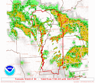
First the setup: We've got a cold front that stretches from Iowa to Oklahoma. Ahead of the front we are starting to see thunderstorms develop. In fact, a Tornado Watch is in effect until 11:00pm for the northern part of Missouri, western Illinois, and southeast Iowa.

Here is a look StormTeam Digital Doppler. The image was taken around 5:30pm CT.
 The Tornado Watch is indicated in the red outline. The yellow outlines indicate Severe Thunderstorm Warnings.
You can see the storms that have popped from Kansas City to Kirksville. The main threat from the storms that have developed is large hail so far.
As I mentioned, the Storm Prediction Center is keeping an eye on things for this evening. They have all of southeast Missouri and parts of southern Illinois, western Kentucky, and northwest Tennessee in a "Slight Risk" area for severe storms. The outlook is good through 7am CT Monday morning.

In the discussion from SPC, they cite a few high-resolution models that keep hinting at thunderstorm development later tonight. Let's take a look at some of the data from the model. Specifically, let's look at the "forecast radar" data some of the models put out.
Here is a view of what the model says the radar will look like at 7:00pm CT this evening. So far the model is doing a really good job.

Here is a view of what the model says the radar will look like at 12:00am CT Monday morning.

Note how the hi-res model tries to develop a second line of thunderstorms in Arkansas. All indications are that this line would move to the east and clip southern parts of the KFVS viewing area (northeast Arkansas, the Missouri bootheel, and northwest Tennessee).
The second line begins to fizzle a bit overnight and looking further in to the model data is moves all the rain north and south of the KFVS viewing area.
The big question for me is whether or not showers and thunderstorms fire further south in to Missouri this evening. I am not sold on that happening just yet.
If we do see storms move through overnight the main threat would be strong winds with some hail. Although, the Storm Prediction Center makes note that it isn't out of the question to have a tornado spin up either. Stay tuned...
Subscribe to:
Posts (Atom)