The 0z (6pm CT) NAM run is now in. That is the latest data available. I am still feeling pretty good about my snowfall forecast. The only thing that might be adjusted is the timing of when the snow gets here. Initially, I was thinking the snow would reach the Cape Girardeau, Missouri area around 8:00pm-10:00pm Wednesday evening. It might start 3 to 4 hours later.
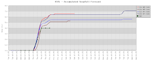
Here is a look at graphs of snowfall accumulation for specific locations around the region.
Cape Girardeau, Missouri:

 Paducah, Kentucky:
St. Louis, Missouri:

Indianapolis, Indiana:

As mentioned earlier, the 0z (6pm CT) run is the latest data. Next is 18z (12pm CT). After that is 12z (6am CT).
No comments:
Post a Comment