Friday, April 30, 2010
Live Streaming Storm Coverage
I will be giving live streaming coverage of the storms tonight as they move through the KFVS viewing area. I'm doing this from home so forgive the lack of video quality.


7:15pm Weather Update
A line of storms is continuing to track across the state of Missouri. Tornado watches blanket the state. There have been a few reports of tornadoes over the southern part of the state near Gainesville, Missouri. We are probably 1-2 hours from it beginning to affect parts of the KFVS viewing area.

I wanted to show you a different look at the line that is moving over the southern part of the state. This is a 3-dimensional look at the line.

If you click on the image you can see different sections I pointed out. For instance, from your vantage point you are looking to the west and "in to the line". To the right of the image is the Northeast. To the left is the Southwest.
The storm that currently has a tornado warning and has had a history of producing a tornado (and damage) is pointed out.
Also note the heights of the storms. The white horizontal lines indicate 10,000 feet. A few of the storms in the line are over 40,000'. The storm that has the tornado warning is topping out a little over 47,000'.

I wanted to show you a different look at the line that is moving over the southern part of the state. This is a 3-dimensional look at the line.

If you click on the image you can see different sections I pointed out. For instance, from your vantage point you are looking to the west and "in to the line". To the right of the image is the Northeast. To the left is the Southwest.
The storm that currently has a tornado warning and has had a history of producing a tornado (and damage) is pointed out.
Also note the heights of the storms. The white horizontal lines indicate 10,000 feet. A few of the storms in the line are over 40,000'. The storm that has the tornado warning is topping out a little over 47,000'.
3pm Weather Update: Moderate Risk Expanded
The Storm Prediction Center has put out their 3pm update to the Day 1 Outlook. They have expanded the "Moderate Risk" area to cover more of Missouri.

The outlook covers from now until 7am CT Saturday morning.
Here is a look at the specific weather type probabilities.
Tornado:

Hail:

Wind:

The blue "hatched" area under the tornado probability indicates where there is a 10% or greater probability of a tornado EF2-EF5 withing 25 miles of any given point.
A tornado watch is already in effect for the northwestern portion of the KFVS viewing area. I expect other portions of at least southeast Missouri to be placed under a watch before the night is over. This will be a good night to make sure your NOAA Weather Radio is turned on before you go to sleep.

The outlook covers from now until 7am CT Saturday morning.
Here is a look at the specific weather type probabilities.
Tornado:

Hail:

Wind:

The blue "hatched" area under the tornado probability indicates where there is a 10% or greater probability of a tornado EF2-EF5 withing 25 miles of any given point.
A tornado watch is already in effect for the northwestern portion of the KFVS viewing area. I expect other portions of at least southeast Missouri to be placed under a watch before the night is over. This will be a good night to make sure your NOAA Weather Radio is turned on before you go to sleep.
Tornado Watch #115
The Storm Prediction Center has issued Tornado Watch #115. The watch is in effect until 10:00pm CT Friday night.

A watch means that conditions are favorable for the development of thunderstorms capable of producing 1"+ diameter hail, damaging wind, and tornadoes.
Storms in the watch area could produce hail up to 2.5" in diameter. Wind gusts over 74mph will be possible from thunderstorms. Storms are expected to move to the northeast at 50mph.

A watch means that conditions are favorable for the development of thunderstorms capable of producing 1"+ diameter hail, damaging wind, and tornadoes.
Storms in the watch area could produce hail up to 2.5" in diameter. Wind gusts over 74mph will be possible from thunderstorms. Storms are expected to move to the northeast at 50mph.
11:40am Weather Update
The Storm Prediction Center just issued their new Day 1 Outlook and it now includes parts of southeast Missouri in a "Moderate Risk" for severe weather through 7am Saturday.
 In reading their discussion, there is some concern about the possibility of tornado development in northern Arkansas and southeast Missouri. The potential exists for a strong tornado in that area.
Here are the probabilities with the new outlook.
Tornado:

Hail:

Wind:

I am debating on going out chasing later today. All of the cloud cover around the area concerns me. Clouds usually don't allow the atmosphere to destabilize. However, I can see some of the instability indices that we look at starting to increase over south central Missouri. If I do go chasing, I'll try to put some live streaming video up here on the blog so you can go with me.
 In reading their discussion, there is some concern about the possibility of tornado development in northern Arkansas and southeast Missouri. The potential exists for a strong tornado in that area.
Here are the probabilities with the new outlook.
Tornado:

Hail:

Wind:

I am debating on going out chasing later today. All of the cloud cover around the area concerns me. Clouds usually don't allow the atmosphere to destabilize. However, I can see some of the instability indices that we look at starting to increase over south central Missouri. If I do go chasing, I'll try to put some live streaming video up here on the blog so you can go with me.
Storms Tonight Through Weekend
The weather is going to be active for the next 72 hours or more. It looks like there will be chances for severe weather and heavy rain.
First lets talk about the thing that looks pretty sure. Heavy rain. We are going to have a front that stalls out around the central United States. This is going to allow for moisture to stream up from the Gulf of Mexico. As the moisture encounters the front it will be lifted and become rain.
Here is a look at this morning's 12z (7am) run of the NAM forecast model. The below graphic shows accumulated precipitation for the 72 hour period starting this morning at 7am and ending at 7am Monday morning.

The model is showing anywhere from 1" to as much as 9" of rain across the Ohio River Valley. A few specific amounts from the NAM model. (Click the images to see a larger version.)
Now lets talk thunderstorms. The Storm Prediction Center (SPC) has parts of the KFVS viewing area highlighted in their severe weather outlook for today through Sunday morning.
Here is a look at SPC's Day 1 Outlook. This outlook covers from now until 7am Satuday.

Tornado Probabilities:

Hail Probabilities:

Wind Probabilities:

SPC continues the "Slight Risk" for severe weather in their Day 2 Outlook. This covers from 7am Saturday through 7am Sunday.

Reminder: KFVS12 and the Heartland StormTeam has a new way for you to be alerted to severe weather watches and warnings. If you are on Facebook, become a "fan" or "like" KFVS Weather Alerts. Watches and warnings will appear in your news feed. On Twitter you can follow @kfvsweather and watches and warnings will be tweeted. Both services are offered free of charge.
First lets talk about the thing that looks pretty sure. Heavy rain. We are going to have a front that stalls out around the central United States. This is going to allow for moisture to stream up from the Gulf of Mexico. As the moisture encounters the front it will be lifted and become rain.
Here is a look at this morning's 12z (7am) run of the NAM forecast model. The below graphic shows accumulated precipitation for the 72 hour period starting this morning at 7am and ending at 7am Monday morning.

The model is showing anywhere from 1" to as much as 9" of rain across the Ohio River Valley. A few specific amounts from the NAM model. (Click the images to see a larger version.)
- Cape Girardeau, Mo: 3.49"
- Farmington, Mo: 1.22"
- Paducah, Ky: 3.35"
Now lets talk thunderstorms. The Storm Prediction Center (SPC) has parts of the KFVS viewing area highlighted in their severe weather outlook for today through Sunday morning.
Here is a look at SPC's Day 1 Outlook. This outlook covers from now until 7am Satuday.

Tornado Probabilities:

Hail Probabilities:
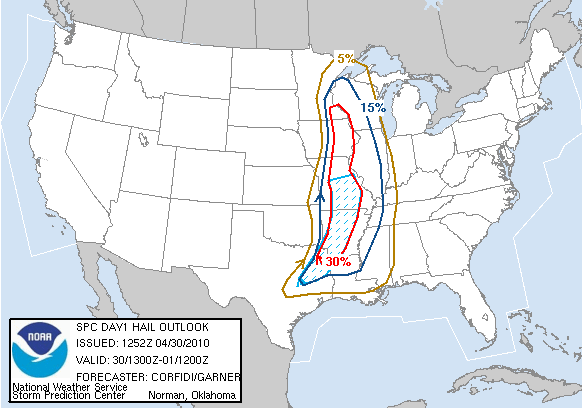
Wind Probabilities:

SPC continues the "Slight Risk" for severe weather in their Day 2 Outlook. This covers from 7am Saturday through 7am Sunday.

Reminder: KFVS12 and the Heartland StormTeam has a new way for you to be alerted to severe weather watches and warnings. If you are on Facebook, become a "fan" or "like" KFVS Weather Alerts. Watches and warnings will appear in your news feed. On Twitter you can follow @kfvsweather and watches and warnings will be tweeted. Both services are offered free of charge.
Wednesday, April 28, 2010
Another Round of Storms
It looks like we are headed towards an active weather pattern. A upper-level low is going to stall out over the southwest United States and will send pieces of energy our way to help spark showers and thunderstorms along a stalled out front that will reside over the Midwest.
The Storm Prediction Center is highlighting portions of the country for severe weather in their Day 3 Outlook.

The above outlook covers the time period from 7am Friday through 7am Saturday.
The SPC is also highlighting an area where there could be severe weather in their extended outlooks.

Specifically the above graphic is pointing out areas that could see severe weather Saturday.
The Storm Prediction Center is highlighting portions of the country for severe weather in their Day 3 Outlook.

The above outlook covers the time period from 7am Friday through 7am Saturday.
The SPC is also highlighting an area where there could be severe weather in their extended outlooks.

Specifically the above graphic is pointing out areas that could see severe weather Saturday.
Saturday, April 24, 2010
11:45am Weather Update
The Storm Prediction Center has put out their new Day 1 Outlook. This covers from now until 7am Sunday.

All of western Kentucky and northwest Tennessee and parts of southeast Missouri and southern Illinois are included in the "High Risk" area. The remainder of the KFVS viewing area is under a "Moderate Risk" area.
Here is the Tornado probabilistic outlook:

Here is the Hail probabilistic outlook:

Here is the Damaging Wind probabilistic outlook:

Everyone should be on their toes today keeping an eye to the sky. Take a minute right now to think about what you are going to do/where you are going to go if a Tornado Warning is issued for your location.
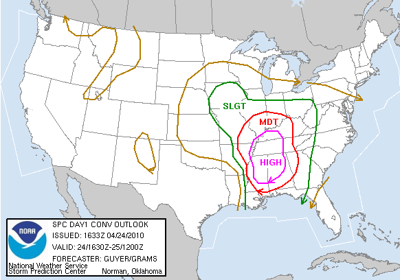
All of western Kentucky and northwest Tennessee and parts of southeast Missouri and southern Illinois are included in the "High Risk" area. The remainder of the KFVS viewing area is under a "Moderate Risk" area.
Here is the Tornado probabilistic outlook:

Here is the Hail probabilistic outlook:
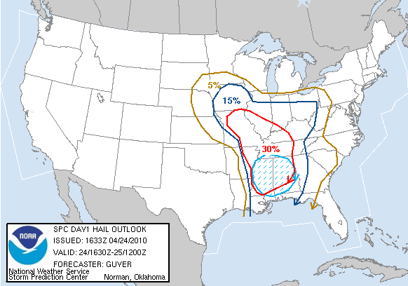
Here is the Damaging Wind probabilistic outlook:

Everyone should be on their toes today keeping an eye to the sky. Take a minute right now to think about what you are going to do/where you are going to go if a Tornado Warning is issued for your location.
Subscribe to:
Posts (Atom)