Showing posts with label Indianapolis. Show all posts

Friday, January 23, 2026

Weekend Storm: Snow Numbers

A significant winter storm is still in the cards for Missouri, Illinois, Kentucky, and Indiana.  If you have plans to travel, you should read this and then reconsider your plans.

Dry air is currently infiltrating the central United States following a passing cold front.  Dew points have dropped below zero, hinting at the arctic origins of the air.

It will take a small amount of time to saturate the atmospheric column, but it should not take long for precipitation to reach the ground as snow.

TIMING:

  • Missouri: Snow will start to enter southeast Missouri from the southwest Saturday morning.
  • Illinois: Snow will enter Illinois late Saturday morning/early afternoon.
  • Kentucky: Snow will enter the extreme southwest corner of Kentucky Saturday mid-morning.
  • Indiana: Snow will enter the southwest corner of the state Saturday afternoon.  It should enter central Indiana late Saturday afternoon.

HOW MUCH:

Computer models have been extremely consistent on how much water will be available in the atmosphere.  There is one computer model that has been consistent with lower water amounts - the GFS.

All that being said, there is copious amounts of water available and there will also be cold air in place.  Snow to Liquid ratios will be higher than normal due to the cold.  Normally, we look at 10 to 1.  For this storm, the ratio could range from 12 to 1 to as much as 18 to 1.

After looking over the Friday morning computer model runs (and the last several days worth of data) these are the numbers I think could fall as snow through Sunday night.

INDIANA 

  • Bloomington: 8"-12"
  • Columbus: 10"-14"
  • Indianapolis: 7"-10"
  • Shelbyville: 8"-11"

MISSOURI

  • Cape Girardeau: 8"-11"
  • St. Louis: 7"-11"

ILLINOIS

  • Carbondale: 10"-15"

KENTUCKY

  • Paducah: 7"-12"

These numbers could still fluctuate as more data comes in over the next 24 hours.  If there is any sleet mixed in, especially in western Kentucky and the Missouri bootheel, it could have significant impact to snowfall amounts.

The attached map may not exactly match what I have forecast above.  It is a display of a blend of computer model snowfall through 7am ET Monday.

Saturday, November 16, 2013

Severe Storms Sunday

The threat for severe weather Sunday continues for parts of the Mississippi River Valley and the Ohio River Valley.

The Storm Prediction Center has placed parts of Illinois, Indiana, Kentucky, Michigan and Ohio in a "Moderate Risk" for severe storms.  They have also placed parts of Arkansas, Illinois, Iowa, Kentucky, Missouri and Tennessee in a "Slight Risk".  The outlook covers the time from 7am ET Sunday through 7am ET Monday.

The population bases within the different risks are pretty high.  Seventy-six and a half million people live within the risk area.  A little over 39-million people live within the "Moderate Risk" and another 37-million live within the "Slight Risk".

Hopefully, people aren't taken by surprise with the potential for severe weather.  November is not an unusual time for severe weather.  In fact, it is the height of the secondary severe weather season for Ohio River/Mississippi River Valleys.

Here is a look at the latest information from the RPM 4km high resolution computer model.

It suggests a line of storms begins to develop and quickly strengthen around 11am Sunday in northwest Illinois.  If this holds true, this could start to bring the line in to the St. Louis metro area shortly before noon.  It would also bring a line of storms near the Chicago metro area around noon.  The model also suggests the line of storms reaching central Indiana between 5pm and 8pm.

IF a line develops further south in to Missouri, the model is suggesting it could start to arrive in southeast Missouri around 12pm-1pm.  The line would continue to move east arriving at the Mississippi River (in southeast Missouri) around 2pm-3pm.

The line mentioned above is likely a secondary line that will develop ahead of a cold front.  Well ahead of the front there could be isolated to scattered thunderstorms later Saturday night through early Sunday morning (pre-dawn) in Missouri, Illinois, Indiana and Kentucky.  There is enough instability to generate a few strong thunderstorms but I think the "main show" will be the secondary line.

There appears to be plenty of instability within the atmosphere to get thunderstorms going.  Here is a look at the CAPE's (a form of instability forecasters look at) from this morning's run of the North American Model at 12pm CT.

CAPES are anywhere between 500 and 1000+ joules/kg for anywhere from Michigan down through Arkansas.

Also, if you step up to around 30,000 feet, there will be tremendous amounts of lift taking place due to divergence in the jet stream starting Sunday morning for areas west and southwest of St. Louis.  Then by late morning a powerhouse jet streak will start to nose in to central Illinois and western Indiana.  Winds will be moving along at 145mph out of the west at 30,000 feet.

Further down the atmospheric column winds will be coming out of the southwest at 55-70 mph just 5,000 feet above the ground.  This being the case, there will be lots of dynamic energy along with turning of the winds throughout the column.  Any thunderstorms that get going can start turning quickly.

I want you to note the probabilities put out by the Storm Prediction Center.

Notice the large 45% probability through the Midwest.  That doesn't mean there is a 45% chance of severe storms for that entire area, however it means that there is a 45% probability of severe weather occurring within 25 miles of any point within that area.

You may also notice the hatched area.  That indicates an area where there is a 10% or greater probability
of significant severe weather within 25 miles of a point.

So what are the main threats?  Right now, it appears that the biggest threat from thunderstorms will be strong, damaging winds.  Also, I think there is a decent tornado threat with this setup.  Especially the further north you go.  For right now, lets say north of I-64 in Illinois in to Indiana.  That means there will be a threat for tornadoes in central/northern Illinois, most of Indiana, southern Michigan and perhaps Ohio.

Since this is a time of year when people aren't thinking about severe weather, make sure you have fresh batteries in your NOAA Weather Radio.  Go over your action place with your family.  What are you going to do/where are you going to go if a Tornado Warning or a Severe Thunderstorm Warning is issued?

FREAK-OUT-METER

Finally, a lot of you ask about my "Freak-Out-Meter".  What is the meter?  It is basically a way for me to try to indicate how much I am concerned about the storm.  Hopefully, for some of you that get freaked out easily from weather it is a way to calm your nerves but also a way for you to see how big of a deal this is.  Keep in mind, this is on a scale from 0-10 with zero meaning I'm not concerned to a 10 meaning I'm beyond concerned.

Central Indiana: 6
Southern Indiana: 5
Northern Illinois: 6
Central Illinois: 5
Southern Illinois: 4
Northern Kentucky: 4
Western Kentucky: 4
Southeast Missouri: 4
St. Louis Metro: 4

Thursday, January 10, 2013

HPC Puts On Their Skates

Taking a quick glance of data this morning concerning Sunday-Monday and the possibility of freezing rain.  Last night’s European computer model (ECMWF) continues to be bullish on the potential whereas NOAA’s global forecast model (GFS) is downplaying the icing side.

One thing the models are in agreement about, rain, heavy at times, will fall Saturday night through early Sunday morning.  A cold front will be slowly moving through Missouri, Illinois and Indiana at the time.  There will be shallow cold air behind the cold front while a few thousand feet up in the atmosphere winds out of the southwest will keep temperatures above freezing.  There are two big questions at this time:
  1. How long will water be available?
  2. Where will be the location of the cold front?
Most likely, just north of the front will see freezing rain.

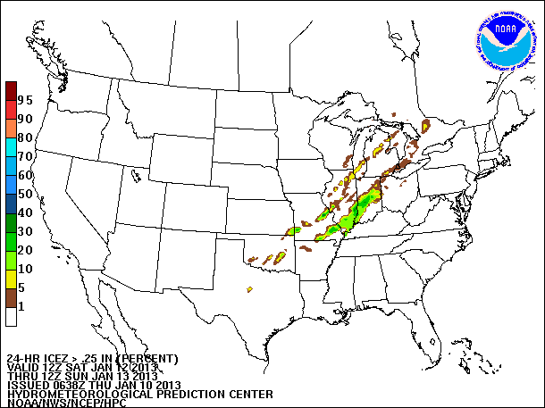
The Hydrometeorological Prediction Center is getting in on some of the freezing rain chatter.  There latest Day 3 Freezing Rain Probability Forecast and Day 3 Freezing Rain Accumulation Forecast is out and includes parts of Arkansas, Missouri, Illinois and Indiana.  The images below look at the Saturday night through Sunday morning time frame.

24-Hour Probability of Freezing Rain Accumulation 0.01”+:
Click the image to see larger version.
24-Hour Probability of Freezing Rain Accumulation 0.25”+:
Click image to see larger version.
48-Hour Freezing Rain Accumulation – 95th Percentile:
Click image to see larger version.
Notice how HPC keeps the freezing rain out of western Kentucky, southern Indiana and northeast Arkansas.  The European computer model has the freezing rain going further south in to those areas.

Will the models continue the way of the GFS, keeping the freezing rain away, or will they lean towards the Euro, hinting at an ice storm?  We’ll have to wait and see what the runs come in with over the coming days.

FREAK-OUT-METER:
  • Southeast Missouri: 3
  • Southern Illinois: 3
  • Western Kentucky: 2
  • Central Indiana: 2
  • St. Louis metro: 3

Wednesday, January 9, 2013

Wet and Slick Weather Ahead

Quite a few weather “things” coming to the Midwest over the next five to six days and there are still a lot of question marks as to what will hit the ground.  One thing is for sure, there will be a significant and beneficial amount of rain falling at least through Sunday.  In some instances, upwards of 6” of rain could fall in parts of Missouri, Illinois and Kentucky.

Here is the Hydrometeorological Prediction Center’s precipitation forecast for the next five days.
Click image to see larger version.
If the computer models are correct, the numbers on the map (above) might be on the low side of reality.  Just through Friday, a four computer model average for rainfall is:
  • Cape Girardeau:  0.96”
  • Indianapolis: 0.89”
  • Paducah: 1.32”
  • St. Louis: 0.96”
Considering much of the area is still well below normal (precipitation), the rains will definitely be beneficial.

CLEAR SLICK STUFF

Now  the main reason for writing this post… What comes Sunday/Monday.

In the next 24-48 hours I think you are going to start to hear television meteorologists/weather-peeps starting to mention “freezing rain” (a.k.a. ice).  Freezing rain isn’t fun as it only takes a very small amount to make things slick.

The temperature profile of the atmosphere will be a HUGE factor in determining what type of winter weather will reach the ground.  It is the changing temperatures with height that makes winter forecasting the most difficult.

Instead of going in to detail how each type of winter precipitation is formed, check out the following links for tutorials from the University of Illinois on how the various winter weather types are formed.
Ok, now that you have a better understanding of how the different precipitation types form, let’s take a look at what some of the computer models are advertising for a few select locations.  (Note:  This is just an overview of what a few locations could see.  The data used is coming straight from computer models and is not the forecast.  It is also subject to change, and likely will.)

For the last couple of runs, computer models are hinting at cold shallow air to be in much of the Midwest.  The cold air is scheduled to arrive late Saturday night through Sunday depending on your location.  The models have temperatures slightly above freezing at 5,000 feet and  how thick that “warm” layer is will determine the type of precipitation hitting the ground.

This is a meteogram for St. Louis.  Each line is a representation of a different run of a computer model’s prediction of freezing rain accumulation.
Click image to see larger version.
The light blue line shows the amount of freezing rain accumulation from this morning’s run of NOAA’s global forecast model, the GFS.  Disregard the dark blue line (comes from the 6z GFS which I hold little faith in).

Not shown in the above meteogram is the European forecast agency’s computer model, the ECMWF.  The Euro is suggesting 0.59” of rain may fall while temperatures at the surface are below 32°F.  (Keep in mind that not all precipitation falling accumulates.  That is a reason for difference in numbers.)

Here are meteograms for a few other locations along with how much precipitation is projected to fall by the Euro.

Cape Girardeau, Mo:   Euro – 0.63”
Click image to see larger version.
Indianapolis, In:  Euro – 0.60”
Click image to see larger version.
As we get closer to Sunday the models should get better at predicting the minute details needed for determining precipitation type. 

Bottom Line… What I want you to take away from all of this is that there is a chance we could see freezing rain Sunday in to early Monday morning (timing varies by location).  It could also fall as all rain or sleet.  There are still considerable uncertainty as to what will fall.

I know many are skittish after the 2009 ice storm but as of today I do not think this will be anywhere near that storm.  As you will see below in my “Freak-Out-Meter”, I don’t think you should be freaking out nor should you be stocking up supplies to go weeks without power.  Instead, what I think you should do is keep an eye on the forecast over the next couple of days, maybe beat the lines and grab a can of deicer and a few batteries.  Worst case (for me anyway), this doesn’t pan out and you’ve got an extra can of deicer and batteries.

FREAK-OUT-METER:
  • Southeast Missouri: 2
  • Southern Illinois: 2
  • Western Kentucky: 2
  • Northeast Arkansas: 2
  • St. Louis Metro: 3
  • Central Indiana: 2

Wednesday, January 2, 2013

Snow Covers Far and Wide

Amazing what four days can do to for a winter’s snow totals.  Two storms and in some cases more than 20” of snow has fallen across parts of the Midwest.

It all started last Tuesday/Wednesday as upwards of 18” of snow fell in parts of Missouri, Illinois and Indiana.  Then Friday night/Saturday morning another couple of inches of snow fell.

According to the National Operational Hydrologic Remote Sensing Center, 76.6% of the Midwest was covered with snow this morning.

(January 2, 2013 Snow Depth - Click image to see larger version)

Compare that to a year ago when only 0.6% of the Midwest was covered.

(January 2, 2012 Snow Depth - Click image to see larger version.)

Even a person not great at math can figure out that is a HUGE increase in snow.

Nationally, as of this morning 65.8% of the continental United States was covered by snow.  Whereas last year only 18.7% was covered.

(January 2, 2012 Snow Depth - Click image to see larger version.)
For those of you that do not like snow, you will like the next 6-8 days as forecast models suggest a quiet weather pattern.  Temperatures may even moderate a little early next week but winter is far from being done.

Friday, December 21, 2012

4:30pm Weather Update - Winter Weather

A quick look ahead at what a couple of national government forecast agencies are showing for Christmas Eve and the Post-Christmas Storm I mentioned in my previous blog post.

First Sunday night through Christmas Eve.  There is potential for parts of Missouri to central Indiana will encounter some light moisture being spread up from the south.  The moisture will encounter cold air near the surface.  Whenever you mix warm air a few thousand feet up and cold air at the surface you can get freezing rain.  This may be the case Sunday - Monday.

The Hydrometeorological Prediction Center has put out their probability forecast for freezing rain that covers 6pm CT Sunday through 6pm CT Monday.
(Click the image to see larger version.)

HPC indicates a heightened probability of freezing rain from roughly St. Louis to Indianapolis along and north of I-70.  Not great for travelers during that time period along a major interstate.

The one bit of "good" news is that it should be light.  Generally less than 0.10".  However, it doesn't take much to make driving "interesting".  This isn't set in stone so if you plan on traveling be sure to check the latest forecast.

Also want to show you what the Climate Prediction Center has highlighted in the Day 3-7 U.S. Hazardous Weather Outlook.
(Click image to see larger version.)

They are highlighting an area of "heavy snow" December 25 through December 26.  So it looks like they are on board with the Post-Christmas Snow Storm.  Although, this is subject to change and likely will wiggle around as computer models crunch the numbers.

Wednesday, December 19, 2012

9:00pm Weather Update - Winds of Concern

Seems like I've been talking about a lot of different type of weather the last two days.  Thunderstorms, tornadoes, snow and wind.  I want to take a minute and talk about the wind for Thursday.  It is going to be strong.

In the St. Louis area they could be sustained 30-35mph with gusts to 45-50mph tomorrow afternoon.  Indianapolis they could be 30-40mph with gusts to 50mph.

At times tomorrow the wind is going to be hauling just a few thousand feet up in the atmosphere.  Here is a cross section of what the 18z NAM computer model is projecting winds to look like at different altitudes tomorrow for St. Louis.  To give a frame of reference, each colored line indicates what the wind speed will be doing.  The white horizontal lines are indicators of height in thousands of feet.  Look to the right of the image to see the altitude.  (1k = 1,000 feet)  Finally, time goes from right to left.  Yes, backwards.  I didn't write the program. ;)

(Click the image to see larger version.)

Notice the area pointed marked with the "Strong Winds Aloft!" arrow.  Those are winds that will be 70-75 mph 2,300 feet above the ground.  Go lower in the atmosphere and they are 46mph at 500 feet.  That is pretty close to the surface.  There will be times that we can mix down some of the stronger winds aloft.  That is why there has been talk of strong winds in the Midwest tomorrow.

Here is another graphic I want to show you.  This is off the high resolution 4km RPM computer model.  I have used this product several times in the past with some success (ice storm 2009 in southeast Missouri and western Kentucky).  This uses alogrithms developed for energy companies and energy traders.  This shows potential power outage areas due to weather elements.  This can caused be a mixture of wind, snow, hurricane, ice, etc.

(Click the image to see larger version.)

Special thanks to Brian Wilkes at FOX59 in Indianapolis for passing this along.

Take a look over Missouri and you will see that the model is indicating "widespread" to "extensive" power outages over north central and west central Missouri to northeast Missouri.  It also shows "scattered" power outages over parts of southeast Missouri, extreme southern Illinois and all of western Kentucky.  If you live in any of these areas, this might be something you have to deal with.  That being said, this is definitely not a guarantee.  The model can be wrong and sometimes is.  Also, don't get too hung up on the lowest threshold "scattered".  This means there could be a "heightened" threat.

12pm Weather Update - Talking Snow

Let’s get a little more in to the snow discussion.  Specifically, how much and for who.  I’ve put together a matrix of cities and various computer models’ snow output.

To begin with, here is the 12z snow accumulation projection from the high resolution RPM forecast model.  The model run covers snow through 6am CT Saturday.
(Click the image to see larger version.)

Heaviest snows will fall from southern Nebraska, central Iowa, southern Wisconsin and northern Michigan.

Now to the matrix.  These are for various locations across the Midwest.

CITY
12z NAM
12z GFS
12z RPM
12z EURO
AVG
Cedar Rapids, IA
8.2”
10.3”


9.3”
Columbus, IN


0.3”

0.3”
Bloomington, IN
2.2”

1.3”

1.8”
Indianapolis
1.4”
0.6”
0.7”

0.9”
Lafayette, IN
1.4”
0.9”
0.2”

0.8”
Moline, IL
3.8”
2.3”


3.1”
Muncie, IN
1.7”
1.5”
0.8”

1.3”
St. Louis
0.0”
0.1”
0.1”

0.1”

I will continue to update the matrix as more model data comes in.  This way, you can see what the various models are indicating.

Wednesday, September 7, 2011

And He's On It

In the words of the late Indianapolis Motor Speedway public address announcer, Tom Carnegie, "And he's on it."

Yes, that is right. I am going to be back on the television giving you the latest forecast. You can watch my forecast starting this Saturday on Fox59 News at 10 on WXIN-TV in Indianapolis, Indiana.

I will be working as one of the weekend meteorologists at the station for three weeks this month.

Don't worry, if you don't live in central Indiana and can't get the station on television, they stream their newscasts live on their website - www.fox59.com. Keep in mind that Indiana is in the eastern time zone. The 10pm ET news will be on at 9pm ET in Missouri, Illinois and western Kentucky.

Currently scheduled dates I will be on Fox59 News at 10:
  • Saturday, September 10
  • Saturday, September 17
  • Sunday, September 18
  • Saturday, September 24
  • Sunday, September 25
I am excited for the opportunity to work on-air for Fox59. Having grown up in central Indiana I always watched the weather people on the Indianapolis television stations. So this fulfills a goal I have had since I was 15 years old. That goal, to get on-air as a weatherman in Indianapolis.

I am not a total stranger to WXIN. During the summer of 1997 I interned in the weather department with the station's chief meteorologist, Brian Wilkes. After the internship ended they couldn't get rid of me. I stuck around and helped out in the weather department when storms would move through the state. In many ways I became an apprentice to Brian. Most of my forecasting "know how" has come from him.

After college I was looking for a weather position at a television station. Eventually, I was offered the position at KFVS-TV in Cape Girardeau, Missouri. However, there was a three month period between college and my start at KFVS. To fill the space I worked as a sports videographer for Fox59. It was a lot of fun as I was able to cover the Indianapolis Colts, the Indianapolis Indians, the NHRA Bud Shootout, PGA golf, college football and high school football.

Hope you will catch me on the tube over the next couple of weeks!

Monday, July 11, 2011

Its Sweating Time

It is going to be a story you hear talked about on the national news for a couple of days. It is getting hot outside! Temperatures across the Midwest this afternoon are climbing to the middle 90's to 100° while the heat index climbs above the century mark.

High temperatures of the day:
  • St. Louis: 100°
  • Cape Girardeau*: 98°
  • Marion, IL*: 97°
  • Paducah*: 97°
  • Louisville*: 96°
  • Indianapolis*: 95°
  • Columbus, IN*: 95°
*Temperatures are indicating hourly observation high temperatures. Official highs for the day will come in later this evening.

Along with the high temperatures, dew points have climbed in to middle 70's (even 80° around Louisville). This is creating heat indices (the feel like temperature) in the 110°-115° range across much of the Midwest. Remember that the dew point is a specific measure of the moisture in the air. Dew point is much more accurate at depicting how humid it is compared to the relative humidity. I know, it sounds weird but its true.

A cold front will slowly move south across the Midwest Tuesday. It should allow for some slightly cooler, less humid air to move in to central Indiana and the St. Louis metro area. However, places like southeast Missouri, western Kentucky and places further south may see a slight increase in temperatures tomorrow as the air is compressed along the front. Typically, air just along and ahead of the front will get warmer than forecast models indicate.