Taking a quick glance of data this morning concerning
Sunday-Monday and the possibility of freezing rain. Last night’s European computer model (ECMWF)
continues to be bullish on the potential whereas NOAA’s global forecast model
(GFS) is downplaying the icing side.
One thing the models are in agreement about, rain, heavy at times, will fall Saturday night through early Sunday morning. A cold front will be slowly moving through Missouri, Illinois and Indiana at the time. There will be shallow cold air behind the cold front while a few thousand feet up in the atmosphere winds out of the southwest will keep temperatures above freezing. There are two big questions at this time:
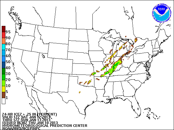
The Hydrometeorological Prediction Center is getting in on some of the freezing rain chatter. There latest Day 3 Freezing Rain Probability Forecast and Day 3 Freezing Rain Accumulation Forecast is out and includes parts of Arkansas, Missouri, Illinois and Indiana. The images below look at the Saturday night through Sunday morning time frame.
24-Hour Probability of Freezing Rain Accumulation 0.01”+:
One thing the models are in agreement about, rain, heavy at times, will fall Saturday night through early Sunday morning. A cold front will be slowly moving through Missouri, Illinois and Indiana at the time. There will be shallow cold air behind the cold front while a few thousand feet up in the atmosphere winds out of the southwest will keep temperatures above freezing. There are two big questions at this time:
- How long will water be available?
- Where will be the location of the cold front?
The Hydrometeorological Prediction Center is getting in on some of the freezing rain chatter. There latest Day 3 Freezing Rain Probability Forecast and Day 3 Freezing Rain Accumulation Forecast is out and includes parts of Arkansas, Missouri, Illinois and Indiana. The images below look at the Saturday night through Sunday morning time frame.
24-Hour Probability of Freezing Rain Accumulation 0.01”+:
 |
| Click the image to see larger version. |
24-Hour Probability of Freezing Rain Accumulation 0.25”+:
 |
| Click image to see larger version. |
48-Hour Freezing Rain Accumulation – 95th
Percentile:
Notice how HPC keeps the freezing rain out of western
Kentucky, southern Indiana and northeast Arkansas. The European computer model has the freezing
rain going further south in to those areas.
Will the models continue the way of the GFS, keeping the freezing rain away, or will they lean towards the Euro, hinting at an ice storm? We’ll have to wait and see what the runs come in with over the coming days.
 |
| Click image to see larger version. |
Will the models continue the way of the GFS, keeping the freezing rain away, or will they lean towards the Euro, hinting at an ice storm? We’ll have to wait and see what the runs come in with over the coming days.
FREAK-OUT-METER:
- Southeast Missouri: 3
- Southern Illinois: 3
- Western Kentucky: 2
- Central Indiana: 2
- St. Louis metro: 3


