- Rain arrives Saturday. The morning should be fine for mowing. Question remains regarding arrival of rain Saturday afternoon. One computer model keeps a southeasterly/easterly wind which often holds the rain off several hours. Another brings the rain in by late morning.
- Showers hang around Sunday on the backside of an area of low pressure. There could be a few showers lingering in to the early afternoon.
- Dry Monday.
Thursday, April 23, 2020
The More You Kmow: Tracking couple rounds of rain
Mowing is strongly discouraged this evening around central Indiana as rain continues to fall. You will be much happier if you wait for Friday to work in your yard.
Allergy Tracker: Mold sufferers are likely feeling it today
With higher moisture content in the air due to rain it isn't too surprising to see mold is high now now around central Indiana. Mold levels are expected to increase this afternon.
Tree pollen levels are at moderate right now. They are expected to increase to high this afternoon. The highest levels of tree allergens right now are cottonwood, willow, birch, and pine. This afternoon it is projected to include mulberry, maple/box elder, oak, elm, and elder.
Wednesday, April 22, 2020
Driest April in over a decade
It sure seems like we've had a lot of clouds and rain this month but data suggests a different story.
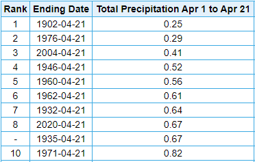
Over half the days this month have produced precipitation - 12 out of 21 days - officially in Indianapolis. Twelve days produced rain and one day produced a trace of snow.only recorded 0.67" of precipitation this month.
Interestingly, the amount of rain for the month is relatively low. Only 0.67" of precipitation has been measured which is quite low. So low that this is the driest April (through the 21st) in 16 years in the Hoosier state capital. This month ties for the 8th driest April (through the 21st) since 1871.
It looks like we will make-up for the dry start to the month with several chances for rain to close April.
Rain returns to Indiana Thursday morning, Saturday, Sunday, Tuesday, and next Wednesday. Long range computer models suggest an additional 1.62" to 2.30" could fall through the end of the month.
Over half the days this month have produced precipitation - 12 out of 21 days - officially in Indianapolis. Twelve days produced rain and one day produced a trace of snow.only recorded 0.67" of precipitation this month.
Interestingly, the amount of rain for the month is relatively low. Only 0.67" of precipitation has been measured which is quite low. So low that this is the driest April (through the 21st) in 16 years in the Hoosier state capital. This month ties for the 8th driest April (through the 21st) since 1871.
It looks like we will make-up for the dry start to the month with several chances for rain to close April.
Rain returns to Indiana Thursday morning, Saturday, Sunday, Tuesday, and next Wednesday. Long range computer models suggest an additional 1.62" to 2.30" could fall through the end of the month.
Allergy Tracker: Tree and Mold allergens climb later today
The grass is green. Trees are beginning to bud. Flowers are beginning to show their colors. 'Tis the season for allergies to kick up.
The latest data shows tree and mold levels are low right now in central Indiana. They are expected to increase later today as winds shift around to the south/southwest.
Grass and weed remains in the clear today.
Tuesday, April 21, 2020
Rare air arrives in central Indiana
Dry air has arrived in central Indiana thanks to a cold front that has passed through the state. The dew point temperature in Indianapolis dropped to 20° officially at 1 p.m. (12:54 p.m. observation). This is definitely more February-like air than late April.
This is extremely rare air. So rare that this is the first time since 1942 the dew point has dropped to 20° or less between April 21-31 in Indy according to data collected from the Midwestern Regional Climate Center.
Friday, April 17, 2020
Wet start to the year and end of work week
It has been a damp, dreary, chilly day around central Indiana today. Northern Indiana even received snow, with as much as 4" of snow reported, late Thursday night in to Friday morning.
Rainfall totals have been relatively light through 4pm. Bloomington has picked up the most with 0.29".
For those of you thinking it has been a wet year you are correct. Take a look at the numbers for Indianapolis.
Indianapolis has received 14.54" of precipitation for the year which is nearly 4" above normal. It currently ranks as the 24th wettest start to a year since 1872.
For those wanting drier conditions it appears there will be dry time coming over the next week. Long range computer models are suggesting anywhere from a third to a half inch of rain possible through 8pm Friday, April 24 in Indianapolis.
Drier conditions start Saturday. So if you need to get yard work done, Saturday is your day. There will be a weak front passing the area Sunday. That could bring a few widely scattered showers throughout the day. Monday looks to remain dry. Another front will pass through early Tuesday morning bringing with it a few light showers.
Rainfall totals have been relatively light through 4pm. Bloomington has picked up the most with 0.29".
For those of you thinking it has been a wet year you are correct. Take a look at the numbers for Indianapolis.
Indianapolis has received 14.54" of precipitation for the year which is nearly 4" above normal. It currently ranks as the 24th wettest start to a year since 1872.
For those wanting drier conditions it appears there will be dry time coming over the next week. Long range computer models are suggesting anywhere from a third to a half inch of rain possible through 8pm Friday, April 24 in Indianapolis.
Drier conditions start Saturday. So if you need to get yard work done, Saturday is your day. There will be a weak front passing the area Sunday. That could bring a few widely scattered showers throughout the day. Monday looks to remain dry. Another front will pass through early Tuesday morning bringing with it a few light showers.
Thursday, April 16, 2020
Coldest temperature for date in 145 years
A second consecutive day with temperatures dropping in to the lower 20°s around central Indiana. It got down as low as 22° just north of Zionsville!
DID YOU KNOW: This was the coldest temperature for April 16 in Indianapolis since 1875 (it dropped to 21°) - ranking the second coldest for the date on record (since 1871).
ADDITIONALLY... This morning was the coldest temperature in #Indianapolis since March 7.
DID YOU KNOW: This was the coldest temperature for April 16 in Indianapolis since 1875 (it dropped to 21°) - ranking the second coldest for the date on record (since 1871).
ADDITIONALLY... This morning was the coldest temperature in #Indianapolis since March 7.
Chance for accumulating snow quickly declining
Lots of talk of snow tonight/Friday for central Indiana but there is light at the end of the tunnel. Historically speaking, the chances for an accumulating snow is quickly dwindling for the Hoosier state capital.
DID YOU KNOW: Since 1931 only 8 days have recorded measurable snow in Indianapolis from this date thru the end of May.
Subscribe to:
Posts (Atom)