Monday, December 2, 2013

End of Week Winter Storm - Monday AM Update

The advertised cold front is still on its way to the southeast.  Temperatures this morning were -20° to -38° in western Canada.

As you can see from this image, temperatures are projected to drop well below normal by Friday afternoon.
Projected Temperature Anomaly - 12pm CT Friday
(Click the image to see larger version.)
Looking at morning data it is becoming clear there will be a storm to deal with Thursday and Friday in southeast Missouri, southern Illinois, western Kentucky, northern Arkansas and southern Indiana.

The new data from the National Weather Service’s Global Forecast model, the GFS, is hinting at the storm being perhaps a little warmer initially.  What does that mean?  The model suggests that things will start out as rain.  And there could be plenty of it initially.  As the cold air wedges in, things change over to freezing rain at the surface.  Eventually, the freezing rain would change over to a little sleet and then perhaps snow.

Here is a look at how much moisture two computer models are suggesting from 12pm Thursday through 6pm Friday.
2-computer model average quantitative precipitation forecast
(Click the image to see larger version.)
When you see the numbers from the GFS you'll notice some hefty amounts.  A lot of that comes down as rain before things change over.  Having said that, freezing rain and then a couple inches of snow on top is not a fun situation.

Here is a closer look at this morning's GFS in a three dimensional sense.  Specifically, we are looking at Cape Girardeau.
12z GFS - Cape Girardeau
(Click the image to see larger version.)
Green vertical bars indicate rain.  Blue indicates snow.  Orange indicates sleet.  Red indicates freezing rain.  Notice the software and the computer model suggest freezing rain during the day Thursday and then changing over to a little snow Friday.

Go a little further north to St. Louis and see what the model is suggesting.
12z GFS - St. Louis
(Click the image to see larger version.)
Notice it is indicating all snow for St. Louis.  In fact, when looking at the 2-computer model average, the data would suggest a 2"-5" snow for the St. Louis area.

Here is a look at snow projections from last night's run of the European forecast agency's model.
0z ECMWF Projected snowfall through 6pm Friday.
(Click the image to see larger version.)

0z ECMWF Projected snowfall through 6pm Friday.
(Click the image to see larger version.)
I would say the Euro is a little more gung-ho with snow versus freezing rain.  Having said that, it still does suggest a little freezing rain for a line from Poplar Bluff to Cape Girardeau and up the Ohio River.  South of that line, the potential for freezing rain is higher.

Also... I am still looking at another chance for snow Sunday in to Monday.  We'll talk more about that as we get closer.

By the way, if you are on Twitter be sure to follow me as I send out many updates throughout the day I typically wouldn't put on the blog.  Follow me at @johndissauer.

Bottom line... No need to panic yet.  Know that there is a good chance of the area seeing something Thursday and Friday.  Know that this could be rain changing to freezing rain and/or sleet changing to snow.

Freak-Out-Meter: 3 out of 10

Sunday, December 1, 2013

End of Week Winter Storm

Things could start getting active this week in the winter weather department.  Bitterly cold air will be on the move from Alaska/Canada and moisture could be coming north through the Mississippi River/Ohio River valleys.

Before I get too far in to this I want to remind you that the items I am going to discuss are still MANY days away.  Things can and likely will change in the forecast.  The data I am going to show you is not the actual forecast but instead a weather computer model projection of what could happen.

Ok, now that all of that is out of the way lets talk about later this week, specifically in Missouri, Illinois, Kentucky and Indiana.

One basic concept we need to discuss before going any further.  Cold air is denser/heavier than warm air.  Hence, hot air balloons rise.

All computer forecast data is indicating COLD air will be on the move through the central United States late Wednesday and Thursday.
Projected Surface Temperature - 6am CT Thursday
(Click image to see larger version.)
The cold front will be somewhere near the Ohio River by Thursday morning.  Again, keep in mind that cold air sinks, so the cold air will undercut warmer air, which will reside a few thousand feet in the sky.

Temperatures at the surface will be dropping and it will be cold at the end of the week and cold for the weekend.  Here is a look at forecast temperatures from the European forecast agency's computer model for Friday afternoon.
Projected Surface Temperature - 12pm CT Friday
(Click image to see larger version.)
Computer models also project a couple waves of energy riding up and over the cold front.  The moisture will be riding in the warmer layer above the ground.  As the moisture falls it will encounter the below freezing air.  Depending on how thick the layer of warm layer and cold layer is will determine what type of precipitation it could be.  In other words, we could be talking a cold rain, freezing rain, sleet and/or snow.

At this point, it is too difficult to say with any certainty the form will be.  We are talking about trying to determine the temperature in a layer of air along with how thick the layer will be (A few hundred feet or thousands of feet?) for something that is 96-120 hours away.  That being said, at this time, I think there potential for snow and/or freezing rain.

What could make this interesting is there could be a couple waves of moisture and there could be ample moisture to work with.

Here is a look at the National Weather Service’s Global Forecast model, the GFS, using a program called BUFKIT.  Specifically, the data is for Cape Girardeau.  Keep in mind when looking at the data, the timeline runs from right to left.
12z Sunday GFS for Cape Girardeau
(Click the image for larger version.)
The colored bars indicate what the program is projecting what form the moisture will fall.  Green = rain | Orange = sleet | Red = freezing rain | Blue = snow.  See all the green and blue?  Right, neither do I.  It is showing up as red.  That means the software/computer model is suggesting it could be falling in the form of freezing rain.

I mentioned "ample moisture".  The GFS is projecting 0.4" to 0.8" of liquid Thursday through early Friday morning for much of southeast Missouri, southern Illinois and western Kentucky.  The European computer model is also putting down some decent moisture (0.5" to 0.8") for the same areas through Friday afternoon.  The one difference is the European model is suggesting it would fall as snow, especially north of the Missouri bootheel and western Kentucky

Also to note, there are hints of another round of moisture coming up through the area Sunday in to Monday.

At this point this is nothing to get concerned over.  My "Freak-Out-Meter" is at maybe a 2 out of 10.  However, I point out the possibilities for later in the week to try and get you to pay attention to the forecast over the coming days.  As more data becomes available, as the computer models are able to sample more of the atmosphere, we will start to get a better idea of what may happen.  As I like to say... Stay tuned.

Bottom line... It is going to turn much colder for the end of the week and the weekend.  There is potential for rain, snow, and freezing rain.

Looking Over December

Hints of a mild Christmas in
 the forecast for 2013.
Just took a look at the experimental loooooong range European forecast computer model.  The model reaches out to December 29.

Before I get in to the observations, let me quickly touch on something coming for later this week.  COLD AIR!!!  This morning at 10am Central, the temperature was -38° in Eagle, Alaska.  Cold air is definitely recharging over interior Alaska.

Computer models have been advertising for days that cold air will be on the march in to the United States for mid to end of the week.  The question all along has been "Just how cold?".  The data has been suggesting VERY cold air but often times the models will start to moderate the temperatures as we get closer to it happening.  This appears to not be the case.

Some of the coldest air in four years could arrive in Colorado by Thursday.  The cold front will pass Wednesday but the brunt of the arctic air arrives a day later.  Ahead of the front, temperatures will be in the 60°s and perhaps 70°s in southern Colorado.  By Friday morning, temperatures could be 60° to 75° degrees colder.  Yes, temperatures look like they could go below zero.  And by Friday afternoon temperatures may struggle to get out of the single digits.

The cold air will push east and arrive in the upper-Midwest Friday and Saturday.  It looks very cold north of I-70 and very VERY cold along and north of I-80.

Now... On to the observations from the long range data...
Looking at 6pm CT December 25.
  • Thunderstorms in the Midwest December 10.
  • Warm-up in Colorado December 12-13.
  • Quiet weather for the United States December 21.
    • Mild temperatures for Colorado, Missouri, Illinois and Indiana.
  • Christmas:
    • Mild weather for Missouri, Illinois, Kentucky and Indiana.
    • Normal to slightly above normal temperatures for Colorado.
    • Snow moving through the Dakotas.
If you are hoping for a White Christmas in the Midwest, the way it looks right now it doesn't look likely.  In fact, there doesn't appear to be a need for winter coats during the afternoon.  Santa Claus may indeed be able to trade in the cold weather jacket for a Hawaiian shirt.

If you are traveling for Christmas, things look A-OK for much of the country on the 23rd and 24th.

As I like to remind... Keep in mind, the model is just that.  A computer model.  The farther out the model looks, the higher the possible error rate.  The key to look at this kind of data is not to look at specifics but instead trends and long wave patterns.

Sunday, November 17, 2013

Storm Reports

At of this writing storms continue to push off to the east through Ohio, Michigan and Kentucky.  I am sure many more storm reports will come in through the night.

As of 7pm Eastern, there have been 77 reports of tornadoes.  296 reports of damaging wind.  40 reports of large hail.

Unfortunately, as now I know of at least four confirmed deaths.  Two in New Minden, Illinois where preliminary survey information puts the tornado at an EF4 with winds at least 166 mph.  There have also been two confirmed deaths in Brookport, Illinois where it appears a tornado passed through the town.

Preliminary information is also coming in from the hard hit town of Washington, Illinois.  Preliminary survey information from the National Weather Service says that at least an EF4 tornado went through the town.  I have seen some reports that have described the town as "leveled with walking wounded".

When looking at the above map, it appears that several of the tornadoes may have been caused by as little as 5 supercell thunderstorms.  One started around the Peoria, Illinois area and tracked northeast through Washington, Illinois and eventually to Chicago's south side.  Another started in Wayne/Stoddard County, Missouri and tracked due east producing tornado reports from Morley, Missouri to Brookport, Illinois and further east in to Kentucky.

National Weather Service survey crews will busy over the coming days to find out what indeed caused the deaths and destruction across much of the Midwest.

10:15am Weather Update: Severe Storms Likely

Just finished looking over data.  To be honest, it is starting to look bad for parts of Illinois and Indiana.  I'm not seeing any new information that says the threat for severe weather is diminishing.

Let me show you what this morning's run (12z) of the high resolution RPM computer model is projection.  What you will see is the model's projection of what the radar will look like through the day.  Please keep in mind, this is not reality, it is just a computer model projecting what could happen.

Here is a look at 1pm ET.

Note that the model is starting to fire up a line of thunderstorms over northwest Illinois.  Also note the individual discrete cells flaring up over central Indiana.  The discrete cells are very concerning during the early afternoon.  If a few discrete storms can get going, they very well could become supercellular and tornado producers.

Here is a look at 2pm ET.

The individual storms are moving northeast across Indiana.  Also, a line of storms is starting to become more organized from southern Wisconsin to St. Louis.  Further south, storms are beginning to develop over southeast Missouri.

What is concerning about this image is the indication of storms beginning to move in to the Chicago metro area.  At that same time, the Chicago Bears game will be in the middle of the second half.  Not good to have tens of thousands of fans in the stands with possible severe storms moving in.

Next is a look at 4pm ET.

The line is becoming better organized as it races to the east.  While there is a line, it is interesting to note that the RPM is trying to suggest we are still looking at more of individual cells along a line instead of all the storms congealing in to one line.  This is not a good thing.  This indicates to me that the potential for tornado development is still very high.  Several strong tornadoes would be possible along this line of storms.

Here is a look at 5pm ET.

Strong to severe storms are now beginning to move in to Central Indiana.  At this point, forecast data suggests storms will be moving east-northeast at 65mph.  These storms will still have the potential to produce strong tornadoes.

Storms are also starting to get stronger towards southern Illinois.

Here is a look at 7pm ET.

The line is now crossing the Indiana/Ohio border and storms are still racing east-northeast at 65mph.  The model also suggests the storms are moving through Columbus, Indiana and approaching the Louisville metro area at this time.

FREAK-OUT-METER:

Moisture is streaming north on southerly winds.  As of 10am ET, dew points were already in the 60°s in Illinois as far north as Chicago.  In Indianapolis the dew point was 59°.  By the afternoon the dew points should be well in to the 60°s for Indiana.  The moisture will act as gasoline for the storms to thrive off.

Unfortunately, it does look like a tornado outbreak is likely over Illinois and Indiana.  Hopefully not, but there are too many signs pointing to it today.  Along with tornadoes, damaging winds will be a HUGE threat from thunderstorms.

INDIANA:
  • Central Indiana: 8
  • Northern Indiana: 8
  • Southern Indiana: 6 -- (Columbus: 7)
ILLINOIS:
  • Central Illinois: 7
  • Eastern Illinois: 8
  • Northern Illinois: 7
  • Southern Illinois: 5
KENTUCKY: 
  • Western Kentucky: 4
  • Northern Kentucky: 5
MISSOURI:
  • Southeast Missouri: 4
  • St. Louis Metro: 4
OHIO:
  • Western Ohio: 6

High Risk Expanded

The Storm Prediction Center has expanded the "High Risk" area for severe storms today/tonight.  The area now includes nearly all of Indiana, much of Illinois, southern Wisconsin, southern Michigan and Western Ohio.

The outlook above is valid through 7am ET Monday.

The BIG concern for today is damaging winds and tornadoes.  The tornado threat is highest in the high risk area.

There is a large population base that lives within the risk areas today.  67-million live in a threat area.  Almost 19-million live within the high risk.

Take today seriously.  If a warning is issued for your location, seek shelter IMMEDIATELY.

Reminder... Follow me on Twitter (@johndissauer) as I will be sending out more real-time updates through that medium this afternoon/evening.

Late Night Data Update: Severe Weather Sunday

Plenty to talk about after looking over the late night computer model data.  We'll discuss timing of storms, what types of severe weather, and an updated Freak-Out-Meter.

COMPUTER MODEL DATA: 

I just looked over the late night computer model run and wanted to give you some idea what the latest high resolution computer models are projecting for Sunday's possible severe weather outbreak.

First, here is a look at the 4km RPM model from the midnight run.  This is looking at the model's projection of what radar imagery will look like at 3pm ET.

At this point the model is suggesting scattered thunderstorms are developing and trying to become more organized in to a line.  Notice the location of the storm clusters.  One up around the Chicago metro area and then it stretches down to southern Illinois and in to southeast Missouri.

One concern with this data... The Chicago Bears are hosting the Baltimore Ravens.  At 3pm ET, the game would likely be in the middle of the second half.  Having tens of thousands of spectators in the stands while severe thunderstorms are moving by is not the best thing.  It will be interesting to see how the NFL handles things tomorrow.

Now we move ahead two hours to 5pm ET.

You can see the line is moving through central Indiana at this point.  A couple things to note.  First, notice the "stronger" looking storms over northern Indiana.  I think that is definitely a possibility.  Also notice the lack of storms from Indianapolis down to Bloomington, IN.  Not sure what to make of that.  Perhaps the model is picking up on something.  That said, don't let your guard down in central Indiana.

Now we skip ahead to 7pm ET.

At this point the model has the line of storms crossing the Indiana/Ohio state line.  Still some very strong, and likely severe, storms moving east.  If this works out to be true, I have a feeling many people in Indiana will be going outside to start cleaning up from the mess left from the storms.

The next two animations are from other high resolution 4km computer models.  They are both running off the WRF model, but they both have different flavors.  One is called the ARW and the other is the NMM.  These animations are courtesy of the people at WxBell.

ARW:

Note that with this model, instead of bringing the bulk of the storms through in one line, it develops two lines of storms.  My guess is the model tries to develop thunderstorms early ahead of the cold front and pushes those east.  Then behind that line, along the cold front, it tries to develop another thin line of thunderstorms.

NMM:

The NMM keeps it similar to the RPM with having one line of storms coming through.

STORM TYPE PROBABILITIES:

Hopefully by now you have seen the latest from the Storm Prediction Center.  A "High Risk" is in place for parts of Illinois and Indiana which includes the cities of Indianapolis, Bloomington (IN), Lafayette, Terre Haute and Champaign (IL).

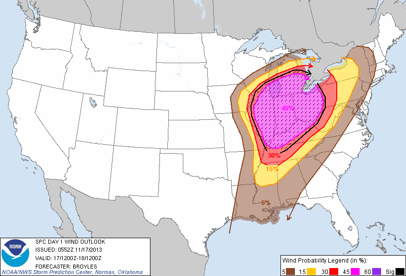
All along the main threats for storms Sunday have been damaging wind and tornadoes.  Now that we are getting closer to the event we can start breaking the threat down more by probabilities.  Here is the Storm Prediction Center's probability forecast for damaging wind.

SPC indicates there is a 45% probability of severe winds for a large part of the Midwest.  The hatched area indicates a 10% or greater probability of wind gusts in excess of 75 mph.

Here is a look at SPC's probability forecast for tornadoes.

In the "High Risk" area they indicate a 30% probability of a tornado.  Perhaps more importantly, look at the hatched area.  It covers a very large area from Cairo, IL to Toledo, OH.  The hatched area means a 10% or greater probability of an EF2-EF5 tornado happening within 25 miles of any point within the area.

That is significant and echos the threat tornadoes will be Sunday.  It doesn't mean there will be a tornado, but it tells me that there is a chance for one, or a few, strong tornadoes.

FREAK-OUT-METER:

Central Indiana: 6
Northern Indiana: 7
Southern Indiana: 4 -- (Columbus: 5.5)

Central Illinois: 5
Eastern Illinois: 6
Northern Illinois: 5
Southern Illinois: 5

Western Kentucky: 4
Northern Kentucky: 4

Southeast Missouri: 4
St. Louis Metro: 4

High Risk - Severe Weather Update

The Storm Prediction Center has placed parts of Indiana and Illinois in a "High Risk". This is only the 5th time a High Risk has been issued in November and is the first since 2005. It is indeed rare.

A "Moderate Risk" includes Illinois, Kentucky, Michigan, Ohio and Wisconsin. Outside of there is a "Slight Risk".  The outlook covers from 7am ET Sunday through 7am ET Monday.

The main threat will be damaging winds and tornadoes. A severe weather outbreak looks likely across parts of the areas.

Please look at previous posts for timing of when storms can be expected in various areas.
This is a potentially dangerous situation for some areas. Also at risk, two NFL games will be taking place in Chicago and Cincinnati. Stay tuned...

- Posted from my iPhone