The Storm Prediction Center has issued Tornado Watch #94. The watch is in effect until 8:00pm CT Saturday night.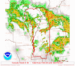 I will be heading in to work soon.
Just a quick post to let you see the latest on today's weather situation.The Storm Prediction Center has more of the KFVS viewing in their "Moderate Risk" area for severe weather today. A Tornado Watch is likely to be issued in the next couple of hours for parts of southeast Missouri, southern Illinois, and western Kentucky.
The National Weather Service in Memphis, TN has expanded Tornado Watch #80 to include Dunklin and Pemiscot counties in southeast Missouri and Clay County, Arkansas. The watch is in effect until 8pm CT Friday. Storms that currently have Severe Thunderstorm Warnings are moving through central Arkansas. At current speed and direction the storms should start to move in to southwestern portions of the KFVS viewing area around 6pm CT.
Tornado Watches are draped over Arkansas, Tennessee, Louisiana, and Mississippi this afternoon. That area will be under a Tornado Watch until 8pm CT this evening.The Storm Prediction Center has put out their latest Day 2 Outlook and they have included more parts of the KFVS viewing area under the "Moderate Risk" area for severe thunderstorms from 7am CT Saturday through 7am CT Sunday. The "Moderate Risk" area now includes parts of southeast Missouri, southern Illinois, all of western Kentucky, and northwest Tennessee.To go along with the outlook, here is the probability chart by the Storm Prediction Center for tomorrow.
 The probability chart shows the percent chance of severe weather occurring anywhere within a given point inside the area. The blue hatched area means that there is at least a 10% chance of significant severe weather occurring.I am getting a little concerned about tomorrow afternoon. Specifically from 1pm-8pm. If this morning's run of the GFS is correct, it could get "interesting" especially in western Kentucky and northwest Tennessee.
It appears likely that an outbreak or two of severe weather will happen over the next 36-45 hours for parts of the country.
There is a lot of data to go over so this will be somewhat short and to the point. There is still a chance for strong to severe storms around southeast Missouri, southern Illinois, western Kentucky, northwest Tennessee, and northeast Arkansas today through Saturday.Here is the latest from the Storm Prediction Center (SPC). This covers now through 7am CT Saturday. Southeast Missouri and southern Illinois are included in the "Slight Risk" area. Northeast Arkansas and parts of the Missouri bootheel are included in the "Moderate Risk" area.Tornado Probabilities*:
 Hail Probabilities*:
 Damaging Wind Probabilities*:
 *Probabilities indicate the percentage that any given point in the area will see that type of weather. It doesn't mean there is a xx% chance of that weather for the entire area.
Here is a look at the severe weather outlook from SPC for Saturday. The outlook covers from 7am CT Saturday through 7am CT Sunday. Here is a look at the overall probabilities of severe weather.
 My thoughts are still pretty much what I said two posts ago (see below).
- First, we will see the possibility of thunderstorms developing along a warm front passes through the area (southwest to northeast) today. However, most of the storms should fire once the front is north of the area. The main threat from these storms would be large hail.
- Decaying storms will move in to the area overnight tonight/early Saturday morning (before sunrise). This line will come from a line of storms from western Missouri/northeast Akansas (if they develop). The main threat from these storms would be damaging wind.
- Thunderstorms will "pop"/initiate over the top of us Saturday. This could start as early as late Saturday morning. As a surface low develops over the top of the KFVS viewing area, there will be a threat for tornadoes on the east side of the low. This would be mainly confined to Tennessee and Kentucky. The main threat with these storms would be large hail, damaging wind, and tornadoes (east of Mississippi).
Note that the biggest concentration will be to the south/southeast of the KFVS viewing area. However, we should still be on the lookout for storms firing Saturday late morning/afternoon.
Heads up everyone. It looks more and more like we will see a chance for severe storms later this week.A storm is moving in to the southwest United States today. This storm will move east across the country. Once it reaches the Plains, ingredients will come together to spark storms in Kansas, Oklahoma, and Texas.By Friday, the storm will have moved east enough to start to get some activity around southeast Missouri, southern Illinois, western Kentucky, northwest Tennessee and northeast Arkansas.Here is the Day 3 Outlook from the Storm Prediction Center. The outlook covers the time period from 7am CT Friday - 7am CT Saturday. A warm front should begin to lift north across the area Friday afternoon. Thunderstorms will pop along the front. That is my biggest concern around the region Friday. Eventually the front should move up to north of St. Louis. Along the warm front the main threat will be large hail and possibly a few tornadoes.Further west, more organized lines of storms will develop and move east. Some of these storms could impact the KFVS viewing area late Friday night through early Saturday morning.SPC has included parts of the region in their Day 4 "heads up". (They don't start putting out Outlook products until day 3.) This covers 7am CT Saturday - 7am CT Sunday.
 All three main severe weather types (damaging wind, hail, and tornado) is possible at this point. We will start to get a better feeling towards what types will be more likely as we get closer to Friday.Here is a look at BUFKIT data specifically for the Cape Girardeau, Missouri area.
 There is a lot of information on the above graphic. I tried to point out some of the specific elements. (Remember, you read it from right to left.)The last month or two I have been concerned with a lack of moisture in the low levels of the atmosphere to sustain severe storms around the area. This won't be the case for Friday and Saturday. You can see that the above model (0z Wednesday GFS) is bringing moisture (dew points) well in to the 60°'s. That is plenty of moisture to sustain severe storms this time of the year.Also note how the model spikes the surface instability Saturday afternoon.Right now I think we could see three rounds of potential severe weather.
- Friday afternoon as the warm front is lifting north across the area. There could also be isolated storms "bubbling up" in the afternoon south of the warm front in the warm sector.
- Overnight Friday in to Saturday when a line of storms could track over the KFVS viewing area. This line will be the line that initiates over eastern Oklahoma/western Missouri. The storms should weaken somewhat, but there will be a lot of upper level support to keep the storms going even with the loss of daytime heating.
- Late Saturday morning/early afternoon storms could initiate over the southern half of the KFVS viewing area and then move east.
The models have been picking up on this system for a while. I first mentioned it on-air Saturday evening on Heartland News at 6pm.
 When the models stay this consistent with a storm system for this long, they are usually on to something.
It has been a quiet severe weather season across the country and it is past time for things to pick-up. Maybe this will be the beginning of a more active pattern.If you haven't gone out to pick up a StormTeam Weather Radio today and/or tomorrow would be a good time to do so. They are still available at Orscheln stores in southeast Missouri, southern Illinois, and western Kentucky for a discounted price of $29.99.Be sure to follow @kfvsweather on Twitter for this event. We have just started a new service with the account. Watches/warnings will automatically be sent out via our Twitter account for the counties KFVS warns. We haven't "officially" launched the service so you are getting a little bit of "insider knowledge", but we are soft launching the addititional data today. We will also be sending out the information to special Facebook account. I am sure you will be hearing more about it in the coming weeks if we are satisfied with the way it performs.
If all goes well, the Space Shuttle (Discovery) will be landing Monday morning at 7:51am CT. I say if all goes well because it looks like there is going to be a chance of rain in the morning for Florida. This could delay the shuttle's landing for a day or two.What is interesting about this landing is the path Discovery will take while re-entering the atmosphere. It looks like the shuttle will be flying over southeast Missouri and northeast Arkansas. Note the speeds what which the shuttle will be gliding while passing overhead.
 It will be traveling at Mach 16 while passing over St. Louis. Mach is another term for the speed of sound. That means the spacecraft will be flying at 16 times the speed of sound. The speed of sound at sea level is 761 mph and at roughly 30,000 feet is 660 mph. This means that the shuttle will be flying at roughly 9,240-10,560 miles per hour while passing over the top of southeast Missouri. Breaking it down even more, this would have the shuttle flying at almost 3 miles per second. Think the cops will set up a speed trap? hahaWhat does all this mean? Don't be surprised to hear a boom or two Monday morning if the shuttle lands. It will probably create a sonic boom or two as it passes over.
My best guess is that the shuttle could be flying over southeast Missouri as early as 6:50am to as late as 7:30am.


