
Sunday, April 5, 2009
Tornado Watch #117
The Storm Prediction Center has issued a Tornado Watch for western Kentucky, northwest Tennessee, southern Indiana, and parts of southern Illinois, and southeast Missouri. The watch is in effect until 6pm CT.


We Have a Hailer
Watching the radar and we have a hailer. It is moving along the St. Francois, Ste. Genevieve, Jefferson (MO), Randolph county lines in southeast Missouri and southern Illinois.

Laura Wibbenmeyer is keeping an eye on the situation at the station. She has made a couple of program interruptions to let viewers know about new Severe Thunderstorm Warnings.
I'll be heading in during the early afternoon.

(The above radar image was taken at 10:26am CT.)
Laura Wibbenmeyer is keeping an eye on the situation at the station. She has made a couple of program interruptions to let viewers know about new Severe Thunderstorm Warnings.
I'll be heading in during the early afternoon.
Storms This Afternoon?
The SPC has a "Slight Risk" for southern Illinois, western/central Kentucky, northwest/central Tennessee, central/southern Indiana. (See below graphic) The outlook from SPC runs through 7am Monday.

It looks like the best time for us to see the stronger storms will be during the afternoon (12pm-5pm).
Forecast models are bringing a jet streak through the area in a favorable way for the development of severe storms. The next graphic is a look at the winds at 500mb. (500mb is approximately 18,000 feet.) See the area of red and purple? That is an area where the winds are moving much faster, approximately 100 knots or 115 mph.

At 10am, temperatures range from the mid-50's in southern Illinois to upper 60's in western Kentucky. Dew points have climbed in to the mid-50's across much of the area.
I am not totally sold on this happening yet. What is keeping my from being sold on the severe weather is the lack of instability. There is a little bit, but not as much as I would want there to be to support the storms.
None the less, the main threat from any strong storms that develops this afternoon is large hail and damaging winds.
Get out and enjoy the warmth today! Temperatures tomorrow will be 25-30 degrees cooler!

Forecast models are bringing a jet streak through the area in a favorable way for the development of severe storms. The next graphic is a look at the winds at 500mb. (500mb is approximately 18,000 feet.) See the area of red and purple? That is an area where the winds are moving much faster, approximately 100 knots or 115 mph.

I am not totally sold on this happening yet. What is keeping my from being sold on the severe weather is the lack of instability. There is a little bit, but not as much as I would want there to be to support the storms.
None the less, the main threat from any strong storms that develops this afternoon is large hail and damaging winds.
Get out and enjoy the warmth today! Temperatures tomorrow will be 25-30 degrees cooler!
Is This Baseball Weather?
If you are looking forward to the start of the Major League Baseball season Monday and plan to watch/go to the Cardinals' home opener, don't get too angry with the weatherman.
The weather is looking pretty lousy for opening day in St. Louis. Lousy as in COLD, not rain. Temperatures are expected to in the upper 30's Monday in St. Louis. Winds will be gusting around 30mph. It will be overcast and there could even be some snow showers.
According to Chad Fryman, first pitch Monday is set for 3:05pm CT. My early estimate as to the temperature Monday afternoon around 3:00pm would be 38 degrees. Chad will be going up to Busch Stadium for Heartland Sports and Heartland News live coverage of opening day. I told him he might want to take a scarf, gloves, a hot water bottle, etc.

By the way, this is a new graphic I made tonight during Heartland News at 10:45pm. We will probably be using it this season when we have time to highlight a Cardinals' baseball game. What do you think?
The weather is looking pretty lousy for opening day in St. Louis. Lousy as in COLD, not rain. Temperatures are expected to in the upper 30's Monday in St. Louis. Winds will be gusting around 30mph. It will be overcast and there could even be some snow showers.
According to Chad Fryman, first pitch Monday is set for 3:05pm CT. My early estimate as to the temperature Monday afternoon around 3:00pm would be 38 degrees. Chad will be going up to Busch Stadium for Heartland Sports and Heartland News live coverage of opening day. I told him he might want to take a scarf, gloves, a hot water bottle, etc.

Thursday, April 2, 2009
Tornado Watch
The SPC has issued a Tornado Watch that includes parts of southeastern Illinois, western Kentucky, northern Tennessee, and southwestern Kentucky. The watch is in effect unil 8pm CT Thursday.
Traffic Drops After Anti-Piracy Law
Interesting article I found today.
"Web Traffic in Sweeden Drops 33% in a Single Day After New Anti-Piracy Law is Enacted"
Thoughts?
"Web Traffic in Sweeden Drops 33% in a Single Day After New Anti-Piracy Law is Enacted"
Thoughts?
12:25pm Weather Update
Rain moving in to southeast Missouri. So far, it is not widespread. However, as we go through the afternoon widespread showers and thunderstorms should move in from Arkansas.
The below radar image is from 12:20pm CT.

The below radar image is from 12:20pm CT.

10am Weather Update - Storms Today?
There could be some big storms across parts of the US today. The majority of the big storms should stay south of the "Heartland" (southeast Missouri, southern Illinois, western Kentucky). However, a few of these big storms could be close. Perhaps as close as Dyersburg, TN and south.
The SPC has the "Heartland" under a "Slight Risk". There is a huge "Moderate Risk" area generally from west Tennessee and south to the Gulf Coast. See the day 1 outlook issued at 7:30am below. The day 1 outlook covers the time period through 7am Friday.

Here is the tornado threat:
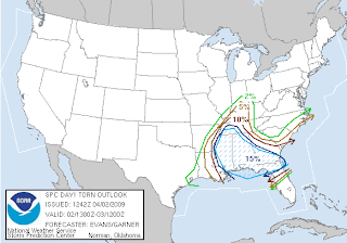
Here is the hail threat:

Here is the damaging wind threat:
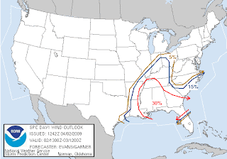
If we see any severe storms, it should happen sometime from 12pm-5pm this afternoon. I think the main threat around here will be large hail and damaging wind. It isn't out of the question for a tornado to spin up around here due to the surface low passing over the top of us. (The surface low generates a lot of spin to begin with.)
One thing that could limit the amount of severe thunderstorms around here is the amount of moisture to work with. At 10am, temperatures range from the upper 50's to lower 60's in the area. Dew points are only in the upper 30's to lower 40's. The dew points will need to really climb (mid 50's+) to sustain stronger thunderstorms. Dew points in Nashville, TN and Memphis, TN are currently sitting in the middle 50's.
The SPC has the "Heartland" under a "Slight Risk". There is a huge "Moderate Risk" area generally from west Tennessee and south to the Gulf Coast. See the day 1 outlook issued at 7:30am below. The day 1 outlook covers the time period through 7am Friday.

Here is the tornado threat:


One thing that could limit the amount of severe thunderstorms around here is the amount of moisture to work with. At 10am, temperatures range from the upper 50's to lower 60's in the area. Dew points are only in the upper 30's to lower 40's. The dew points will need to really climb (mid 50's+) to sustain stronger thunderstorms. Dew points in Nashville, TN and Memphis, TN are currently sitting in the middle 50's.
Subscribe to:
Posts (Atom)