A Tornado Warning has been issued for southern Bollinger County, Missouri. The warning is in effect until 12:15pm CT.
A heads up to people in southern Cape Girardeau County. It looks like this storm will continue to move to the east at 65mph. That would bring the storm in to southern Cape Girardeau County around 12:30pm CT.
I need to get ready and head in to work.
Sunday, March 8, 2009


New Tornado Watch to be Issued
I'm on the conference call with the National Weather Service in Paducah, Kentucky. They just stated that the Storm Prediction Center will be issued a Tornado Watch for all of Southeast Missouri, Southern Illinois, and Western Kentucky in a matter of minutes.
The watch will be in effect until 4pm CT.
Just a reminder... A Tornado Watch means that conditions are favorable for the development of severe thunderstorms capable of producing tornadoes.
The watch will be in effect until 4pm CT.
Just a reminder... A Tornado Watch means that conditions are favorable for the development of severe thunderstorms capable of producing tornadoes.
9:25am Update
Wanted to give you a quick radar update on where the line of thunderstorms is located.
Here is the 9:26am radar data from the Springfield, Missouri radar site.

Here is the 9:26am radar data from the Springfield, Missouri radar site.

The red polygons indicate Tornado Warnings. The yellow poylgons indicate Severe Thunderstorm Warnings.
9am Weather Update
A quick update regarding today's chances of severe weather across southeast Missouri, southern Illinois, western Kentucky, northwest Tennessee, and northeast Arkansas.
As of 9am, there is a Tornado Watch just to the northwest of the listed above area. Here is a radar/watch composite graphic from 9:05am.

Most likely a watch will be issued that will cover parts of southeast Missouri and Southern Illinois in the next couple of hours.
The Storm Prediction Center (SPC) has upgraded parts of the area to a "Moderate Risk" while the remaining area is under a "Slight Risk". See graphic below.

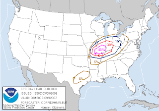
Here are some of the probability products SPC puts out concerning what types of severe weather could be seen.
Here is the large hail product.
Here is the high wind product.

Here is the tornado product.

As you can see, the biggest threat appears to be large hail and damaging winds from storms as they move through.
SPC's next outlook will be issued around 11:30am CT.
The National Weather Service in Paducah, KY has scheduled a conference call for emergency managers and tv meterorologists this morning. They typically do this when a "Moderate Risk" is covering part of their forecast area.
As of 9am, there is a Tornado Watch just to the northwest of the listed above area. Here is a radar/watch composite graphic from 9:05am.

Most likely a watch will be issued that will cover parts of southeast Missouri and Southern Illinois in the next couple of hours.
The Storm Prediction Center (SPC) has upgraded parts of the area to a "Moderate Risk" while the remaining area is under a "Slight Risk". See graphic below.

Here are some of the probability products SPC puts out concerning what types of severe weather could be seen.
Here is the large hail product.

Here is the high wind product.

Here is the tornado product.

SPC's next outlook will be issued around 11:30am CT.
The National Weather Service in Paducah, KY has scheduled a conference call for emergency managers and tv meterorologists this morning. They typically do this when a "Moderate Risk" is covering part of their forecast area.
Saturday, March 7, 2009
Weather Update
Just a quick update before I go in to work. The SPC updated their Day 2 Outlook. See the image below. In their discussion they are talking about the chance of a few possible tornadoes.


I'll have more tonight on Heartland News at 6pm and 10pm. I'll try to update the blog later tonight or early Sunday morning with the latest thinking.
Thunderstorms Sunday?
It still looks like there is a chance for thunderstorms around Missouri, Illinois, Kentucky, Tennessee, Arkansas, and Indiana Sunday. The SPC (Storm Prediction Center) still has parts of those states under a "Slight Risk" of severe weather from 7am Sunday - 7am Monday in their day 2 outlook. (See below graphic.)

Temperatures are expected to be in the 70°'s and dew points are expected to be in the lower 60°'s. So it is going to feel a bit more humid.
There could be a few scattered showers/thunderstorms around the area Sunday morning, but they should behave.
As the day progresses, temperatures/dew points will increase. A cold front will start to sweep in from the west by mid-day. Ahead of and along the cold front more wide spread thunderstorms will develop. This is most likely when the stronger to severe thunderstorms will move through the area. Once the sun sets, we will lose some of the energy as temperatures drop. So storms should quickly diminish in intensity.
It still appears that the main threat will be large hail and damaging winds. However, there is a little turning in the atmosphere, so it isn't out of the question we could see a quick spin-up of a tornado.
Another reminder... Today would be a great time to go out and purchase a NOAA Weather Radio. They can be lifesavers!

Temperatures are expected to be in the 70°'s and dew points are expected to be in the lower 60°'s. So it is going to feel a bit more humid.
There could be a few scattered showers/thunderstorms around the area Sunday morning, but they should behave.
As the day progresses, temperatures/dew points will increase. A cold front will start to sweep in from the west by mid-day. Ahead of and along the cold front more wide spread thunderstorms will develop. This is most likely when the stronger to severe thunderstorms will move through the area. Once the sun sets, we will lose some of the energy as temperatures drop. So storms should quickly diminish in intensity.
It still appears that the main threat will be large hail and damaging winds. However, there is a little turning in the atmosphere, so it isn't out of the question we could see a quick spin-up of a tornado.
Another reminder... Today would be a great time to go out and purchase a NOAA Weather Radio. They can be lifesavers!
Friday, March 6, 2009
Follow me on Twitter
I have joined the Twitter community. (Actually, I have had an account for quite a while when we were testing things for Heartland News/KFVS use.) The new Twitter account is now public.
So follow me on Twitter. I am johndissauer on Twitter. Or you can go to www.twitter.com/johndissauer.
So follow me on Twitter. I am johndissauer on Twitter. Or you can go to www.twitter.com/johndissauer.
Spring is here!
I'm back from vacation and my batteries are recharged. I'll post some pics from the trip a little later (I'm still trying to unpack).
I did want to make everyone aware of the threat of thunderstorms for Sunday. I just sat down and took a look at the Storm Prediction Center's website and noticed that Missouri, Illinois, Kentucky, Tennessee, Arkansas, and Indiana are highlighted with a "Slight Risk" area.

The above graphic is the Day 3 Outlook from SPC. It covers the time period 7am Sunday - 7am Monday. The current forecast discussion from the meteorologists at SPC state that the main threat from thunderstorms will be large hail and damaging wind.
By the way, welcome to spring! Meteorological spring begins March 1.
If you are out and about this weekend, it might be a good idea to pick-up a new battery for your NOAA weather radio. If you don't have one, it would be a perfect time to purchase one.
I did want to make everyone aware of the threat of thunderstorms for Sunday. I just sat down and took a look at the Storm Prediction Center's website and noticed that Missouri, Illinois, Kentucky, Tennessee, Arkansas, and Indiana are highlighted with a "Slight Risk" area.

The above graphic is the Day 3 Outlook from SPC. It covers the time period 7am Sunday - 7am Monday. The current forecast discussion from the meteorologists at SPC state that the main threat from thunderstorms will be large hail and damaging wind.
By the way, welcome to spring! Meteorological spring begins March 1.
If you are out and about this weekend, it might be a good idea to pick-up a new battery for your NOAA weather radio. If you don't have one, it would be a perfect time to purchase one.
Subscribe to:
Posts (Atom)