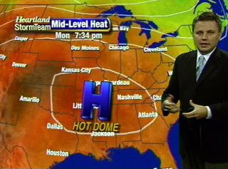
We haven't seen anything yet. All indications are pointing to the hottest air of the summer moving in to southeast Missouri, southern Illinois, western Kentucky, northwest Tennessee, and northeast Arkansas over the next 96 hours.Forecast models are advertising a mid-level high pressure area strengthening and moving over the Mid-Mississippi Valley region starting Monday. The mid-level high will be in place through Wednesday or Thursday. Typically when we have high pressure in place we have decent weather. Relatively clear skies due to sinking air from the high pressure. When you put high pressure up several thousand feet, when the air sinks it begins to compress. A study of physics shows that when you compress air, it heats up. That is what will be happening over the top of the KFVS viewing area.Now the big question, "How hot will it get?" That's a tricky one. We know that the air will have the capacity to heat but we are also going to have moderate amounts of moisture in the air (humidity).The more moisture air holds, the more difficult it is to heat. Good examples... Look at the desert and look at the Gulf Coast. The desert heats very quickly partially due to the lack of moisture in the air. Along the Gulf Coast it gets hot, but rarely do you see it get extremely hot. That is mostly due to the amount of moisture in the air.Models are suggesting dew points in the lower 70's over the next several days. That is a drop compared to where we have been over recent weeks. However, the forecast models have been forecasting dew points too low. It wouldn't surprise me if we've got dew points in the middle 70's if not a little higher. This should keep our temperatures from jumping through the roof.Here is a look at air temperatures from various forecast models. There is a legend to the right of each of the meteograms. In the legend you will see there are two different forecast models being depicted. The GFS and the NAM. The last two runs of the models, 0z (7pm) and the 6z (1am), are shown.Cape Girardeau:
 Farmington, Mo:
 Paducah, Ky:
 Jonesboro, Ar:
 Before you ask (you always do), these are the only sites available with data displayed in the fashion in the KFVS viewing area. Use the locations from above to extrapolate your location.As of now, I don't think we will hit the 100 degree mark. It is very difficult for us to hit 100 degrees around here. I am speaking specifically for Cape Girardeau. I wouldn't be surprised to see Farmington, Mo hit 100 or the Missouri bootheel hit 100 at some point over the next couple of days.By the way, the last time Cape Girardeau officially hit 100 degrees was August 24, 2007. Will we hit the century mark again?
Today marks the first day of the last month of "meteorological summer". We can finally see some light at the end of the tunnel!Let's take a look back at July 2010...Surprisingly, the month turned out to not be as hot for some areas.Temperature departure from normal:- Cape Girardeau, Mo +1.9 degrees per day
- Carbondale, Il +4.4 degrees per day
- Paducah, Ky +3.5 degrees per day
- Poplar Bluff, Mo +1.4 degrees per day
Hottest day of the month:- Cape Girardeau, Mo 96 on July 6
- Carbondale, Il 96 on July 23 and 24
- Paducah, Ky 98 on July 24
- Poplar Bluff, Mo 97 on July 29
You get the idea from the data above that it has been a bit hotter in southern Illinois and western Kentucky. Keep in mind, the thermometer might not have read higher, but it was hotter as compared to what the normal temperature should be.The main culprit for it feeling so hot last month was the humidity. When I am talking about humidity, I am referring to the amount of moisture in the air. The best measure and indicator as to the humidity is the dew point temperature. In basic terms the dew point is the measure of the amount of moisture in the air. (Go here for a full definition of dew point.)As I often say on the television, dew points above 60 degrees starts to make it feel uncomfortable outside. Dew points over 70 degrees makes it feel tropical/very uncomfortable. Dew points through the month of July have been sitting in the middle to upper 70's. That is very humid air. Typically in late July and August we will see dew points in the mid-70's. A couple days I saw the dew point hit 80 degrees which is about as high as you will see. (A few times during the summer you can find dew points in the lower 80's in Iowa over the corn fields.)The dew point is used with the air temperature to calculate the heat index, or the "feels like" temperature. The heat index seems to have been sitting in the lower 100's throughout much of the month. I think the highest I saw it get was around 113 (in Mt. Vernon, Il).So has it been a hot month? Generally speaking.... A little. Has it felt hot? ABSOLUTELY!July also turned out to be relatively dry. If I had a nickel for every time someone has told me, "It hasn't rained here all summer. It will rain two blocks from my house, but not at mine. Bring me some rain." I could be sitting on a beach sipping drinks with no worries.Let's take a look at July's rainfall numbers.Precipitation departure from normal:- Carbondale, Il -1.85"
- Paducah, Ky -3.09"
- Poplar Bluff, Mo +0.40"
As you can see, it again depends on where you live. Some areas have been around normal and others have been well below normal.It is interesting to compare the precipitation departure from normal to the temperature departure from normal. Notice that the areas that are well below normal for rainfall are the areas that are quite a bit above normal for temperature. This is not abnormal. In fact, it is to be expected.
A complex of thunderstorms has moved from the St. Louis area to parts of southeast Missouri and southern Illinois. The line appears to have joined Weight Watchers and is thinning. I don't expect much in the way of severe weather.Here is a view of the radar image from the Paducah NWS radar site at 11:55am CT. The Storm Prediction Center isn't anticipating having to issue a watch for the line of storms, however they are keeping an eye on the area. There doesn't appear to be as much instability across the area as compared to the last couple of days. One of the biggest reasons is the cloud cover blanketing the area.
 I'm in for Bob this afternoon and evening, so check in on Heartland News at 5, 6, and 10 and of course on KFVS12.com/weather for the latest.
We've got some storms moving in to the KFVS viewing area this morning.A Tornado Warning is in effect until 10:45am CT for parts of St. Francois and Ste. Genevieve counties in southeast Missouri. Some of the cities included in the warning include Farmington, Weingarten, Libertyville, and Coffman.Here is a look at the radar image from the St. Louis NWS site at 10:23am this morning. The warning is based off of radar and nothing has been spotted. I've been keeping an eye on it and I haven't noticed too much rotation with the storm.The complex of storms is beginning to move in to southern Illinois and further south in to southeast Missouri. The big question is how much momentum is there behind the complex and how long will it hold together. I wouldn't be surprised to see the complex start to fizzle out in the next hour or so. However, the complex is moving in to a fairly unstable air mass.At its current speed and motion rain will start to move in to Carbondale, Il, Benton, Il, and Greenville, Mo around 11:05am, and if the storm continues to hold together Cape Girardeau, Mo around 11:35am, Bloomfield, Mo around 11:40am. (All times approximate.)Currently, there is a Severe Thunderstorm Watch that is in effect until 1pm CT that includes the following counties in southeast Missouri: Iron, Madison, Reynolds, St. Francois, Ste. Genevieve and in southern Illinois: Randolph and Washington.
The Storm Prediction Center has included most of the KFVS viewing area (southeast Missouri, southern Illinois, northwest Tennessee, northeast Arkansas, and western Kentucky) in a "Slight Risk" area for severe thunderstorm development. The outlook from SPC runs from now through 7am CT Friday.The main threat appears to be damaging wind from storms that develop.
The Storm Prediction Center has issued Severe Thunderstorm Watch #450 for southern Missouri. The watch is in effect until 4:00pm CT Sunday. It includes parts of southeast Missouri. A complex of thunderstorms has developed southeast of Kansas City. The thought is that the storms could continue to move/develop south/southeast along a semi-stalled front that runs from roughly the Missouri bootheel to northwest Missouri.The main threat from the thunderstorms will be damaging wind and large hail up to 2" in diameter. Storms are expected to move east/southeast at 45 mph.Just a reminder... You can get severe weather watches and warnings sent to you instantly via Facebook and Twitter for free. Just "like" KFVS Weather Alerts on Facebook and follow kfvsweather on Twitter.
Is it hot enough for you? Believe it or not, I have had several people tell me they like this hot and humid weather. Personally, I'll pass. Put it back in the middle to upper 80's and drop the dew points to the 50's and I'd be much happier.June turned out to be a hot month for the entire KFVS viewing area. Take a look at some of the statistics:Cape Girardeau, Mo:- Average temperature: 80.7
- Departure from normal: +5.0
- Days above 90: 19
- Days above 94: 9
- Warmest day of month: 97 (6 times: 13, 14, 15, 21, 22, 26)
- Monthly rainfall: 1.66"
Carbondale, Il:- Average temperature: 79.9
- Departure from normal: +7.2
- Days above 90: 16
- Days above 94: 6
- Warmest day of month: 95 (6 times: 12, 14, 15, 21, 22, 26)
- Monthly rainfall: 3.34" (1.43" below normal)
Paducah, Ky:- Average temperature: 79.6
- Departure from normal: +5.1
- Days above 90: 13
- Days above 94: 0
- Warmest day of month: 94 (3 times: 20, 21, 22)
- Monthly rainfall: 2.74" (1.77" below normal)
Poplar Bluff, Mo:- Average temperature: 82.4
- Departure from normal: +6.4
- Days above 90: 24
- Days above 94: 13
- Warmest day of month: 99 (2 times: 20, 21)
- Monthly rainfall: 0.55" (3.41" below normal)
June 2009 saw similar numbers and then July ended up below normal. Keep your fingers crossed if you want some cooler weather!