Sunday, February 27, 2011

8:00am Weather Update 2/27

Eyes are still focused on later this afternoon and overnight tonight.

A storm system is beginning to develop over northern Texas, southeast Colorado and southwest Kansas. The surface low pressure should continue to deepen through the course of the day.


A warm front extends out from the surface low. The warm front should lift north across the KFVS viewing area through the morning and early afternoon. South of the front temperatures are currently sitting in the 60's and dew points are in the 60's. Dew points in the 60's for this time of year will give plenty of moisture to fuel thunderstorms later today.

The Storm Prediction Center has the KFVS viewing area in a Moderate Risk and Slight Risk for severe weather in their latest Day 1 Outlook. The outlook covers the time period from now until 6am Monday.


Often times I will talk about the "main threat" from the storms. Tonight's main threat will be damaging wind, large hail and strong tornadoes.

Now that we are within the Day 1 time period we can look at probability forecasts for specific weather.

Here is a look at the SPC's tornado probability forecast.


The bullseye is right over southeast Missouri, western Kentucky, northwest Tennessee, extreme southern Illinois and northeast Arkansas. A 15% probability for the tornado product is pretty significant. Also note the blue hatched area. That is where the SPC thinks there could be a strong tornado of at least EF2 strength.

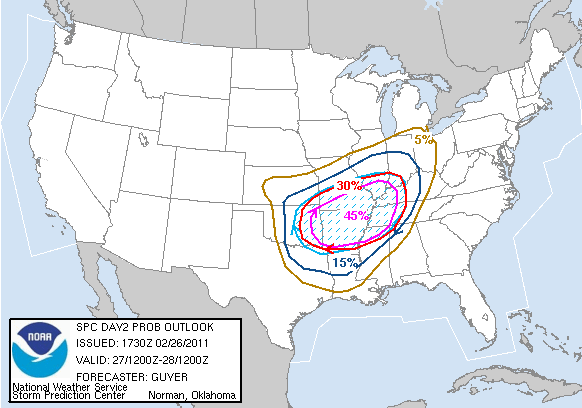
Here is a look at the SPC's damaging wind probability forecast.


The window of opportunity is rather wide. We could see individual thunderstorms as early as this afternoon along the warm front or even south of the warm front. Some of these storms could contain large hail and develop tornadoes. It will not take long for some of the storms to develop in to strong or severe storms.

I am still looking for the "main event" to happen later tonight and continue through the overnight hours. Generally speaking I am looking at the time from roughly 9pm Sunday through 9am Monday.

The one thing I, along with others in the weather community, am concerned about is the timing of the main event. It will move through during the overnight when most are sleeping. A study conducted by Northern Illinois University shows that tornadoes that occur during the overnight period (midnight to sunrise) are 2.5 times as likely to kill as those occurring during the daytime.

The findings along with local/regional research by the NWS concluded:
  1. The public is less likely to receive warnings issued at night.
  2. The public is more likely to be in more vulnerable housing and building structures at night.
  3. Mobile homes are the leading location for tornado fatalities.
  4. Tornado fatalities are enhanced during the late fall and winter.
  5. Our region (southeast Missouri, southern Illinois, western Kentucky, southwest Indiana) has among the highest percentage of nighttime tornadoes and nighttime tornado fatalities of anywhere in the U.S.
Other startling statistics for southeast Missouri, southern Illinois, western Kentucky and southwest Indiana:
  • 34 of the 38 (89.5%) tornado deaths since 1996 have occurred at night.
  • 29 of the 38 (76.3%) occurred between midnight and sunrise.
  • 30 of the 38 (78.9%) tornado deaths were in mobile homes (2 in permanent homes).
I am not telling you the above information to scare you. I am using it to inform you. I am hoping that you have a plan of action for tonight. It has been several months since we have had to deal with a widespread severe weather event. It is February, most people aren't thinking about severe weather. They are thinking more about snow. It is the weekend, so people may not be paying as much attention to the forecast.

Should you be freaking out about tonight? Absolutely not. Should you be aware? Absolutely! Have a way to be alerted to warnings tonight. Turn on your NOAA Weather Radio. Leave a tv on and have someone keep and eye on the weather. Take a few minutes to think about what you should do if a Tornado Warning is issued at 2am. Where do you go? Once you have this figured out, go over it with the rest of the family. Talk to your kids. Make a game of it. Have them practice it this afternoon. If they go over it once or twice, hopefully they won't be as scared if they have to do it later tonight or later this spring.

On a side note, I can remember as a child going to the basement at all different times of the day/night for tornado warnings. My parents were very good about it. They kept level headed, didn't panic and in return it didn't cause my brother or I to panic. We headed to our different spots in the basement and turned on the tv and radio.

Again, I am not trying to scare you. Information can be valuable if you use it with a level head. The storms overnight will be moving at a fast pace. You may only have a couple of minutes of warning before the storm is on top of you.

Saturday, February 26, 2011

7:00pm Weather Update 2/26

Area Upgraded 2/26

The Storm Prediction Center has just issued their new Day 2 Outlook and it now includes the entire KFVS viewing area in a "Moderate Risk" for severe weather from 6am Sunday through 6am Monday.


Also included in the Moderate Risk area: Little Rock and Memphis

The forecaster at SPC has also increased the probability area and the hatched area. (See previous post for more information about probabilities and hatched areas.)


I am just reading through the discussion by the forecasters that prepared the above outlook. They say, "A regional outbreak of severe thunderstorms... including the possibility of widespread damaging winds/strong tornadoes... seems probable late Sunday afternoon and especially Sunday night."

Again... If you do not have a NOAA weather radio I STRONGLY suggest picking one up today or tomorrow. The storms will most likely come through during the overnight hours while many are sleeping. The radio will alert you to warnings as they are issued overnight.


I also suggest that you purchase a NOAA weather radio with S.A.M.E. technology. This allows you to program individual counties so you are only alerted for those specific locales.

You can pick-up a StormTeam Weather Radio at Orscheln stores around southeast Missouri, southern Illinois and western Kentucky for $29.99. More information at www.kfvs12.com/weatherradio.

It is also a good time to give yourself a little "Severe Weather Safety Check Up". If a tornado warning is issued for your location in the middle of the night, what will you do? Where will you go?

I will be working this severe weather event. Depending on how busy it gets and if there is interest, I may take my laptop and webcam in to work and put a live stream up here on my blog.

Another Round of Storms 2/26

Meteorologists are keeping their eyes on a storm system that could bring another round of severe weather to southeast Missouri, southern Illinois, western Kentucky, northwest Tennessee and northeast Arkansas.

The upper-level portion of the storm of interest is located over western California this morning. You can see the storm by looking at a satellite loop at this link.

All models are bring the storm off the west coast and moving it over the Midwest late Sunday night and early Monday.

The good news/bad news about the storm is that it will be coming during the overnight hours and during the morning hours. That is good as we won't have the heating of the day to help intensify storms. However, this system looks to have a large amount of support in the upper-levels and with the wind field, along with moderate instability, storms will still be able to thrive.

It is bad because most people will be sleeping as it moves through. Injuries and death statistics rapidly increase when storms move through areas during the overnight hours.

The Storm Prediction Center has the entire KFVS viewing area included in a "Slight Risk" area in their latest Day 2 Outlook.


Places included in the "Slight Risk" area include Tulsa, Springfield (IL and MO), Indianapolis, Nashville, Louisville, Memphis and Little Rock.

The above outlook covers the time period from 6am Sunday through 6am Monday.

Another product from the Storm Prediction Center at the Day 2 level is the probabilities of severe weather.


The probability forecast is generated by forecasters at the Storm Prediction Center. The areas indicate the probability of any type of severe weather (wind, hail, tornado) occurring within 25 miles of any point. The blue hatched area indicates a 10% chance of significant severe weather occurring within 25 miles of a point.

I took a look at some of the new computer model data from this morning. There is considerable support for severe weather in the upper-levels of the atmosphere.

Models are showing a lot of divergence taking place in the upper-levels in south/southeast Missouri starting around 9pm CT Sunday night. The diverging air allows air to rise. Models are also showing the nose of the strongest part of the jet stream, a jet streak, will be pushing in to the area Monday morning.

Instability is there. It isn't high like you see in spring and summer, but for February, it is plenty high enough to spark thunderstorms.

Right now, my feeling is that we could see two rounds of storms in the KFVS viewing area. The first occurring late Sunday night (8pm Sunday - 2am Monday). This time period could spark individual storms. The second time period would be from 5am Monday through 10am Monday as a line of thunderstorms moves through.

Damaging wind should be the main threat from the storms. However, a couple of tornadoes could spin up with the wind environment.

A new SPC Day 2 Outlook should be out within the next hour. I wouldn't be surprised to see the SPC upgrade parts of the area to a Moderate Risk sometime between now and tomorrow morning. I'll try to get an update published this afternoon.

Just a reminder... Since we are talking about overnight storms, make sure you have a way to be alerted to severe weather warnings so you and your family can take action. A great way to be alerted in the middle of the night is to have a NOAA weather radio. I HIGHLY suggest having one. I believe they are just as important as smoke detectors. Every house and every business should have one.

Thursday, February 24, 2011

12:15pm Weather Update 2/24

It still appears that the KFVS viewing area will be on the fence between severe storms or just heavy rain.

The Storm Prediction Center still has most of the KFVS viewing area in a "Slight Risk" for severe weather and parts of the area in the "Moderate Risk" area. The outlook runs from now through 6am Friday.

Day 1 Outlook


A warm front to our south is forecast to drift a little further north during the afternoon and evening. The warm front's northward progression will partially depend on the track of the surface low.

At last check, it appears that the surface low will move overhead of southeast Missouri, western Kentucky and southern Illinois. If this happens, warmer air will begin to surge north at some point.

I am thinking the best chance for severe thunderstorms would be between 7pm and 11pm this evening. As far where could the severe weather be located in the KFVS viewing area? I'm thinking somewhere along and south of a line from approximately Neelyville, Missouri to Sikeston, Missouri to Mayfield, Kentucky (aka extreme southern parts of western Kentucky, northwest Tennessee, northeast Arkansas and the Missouri bootheel plus)

The main threat from the storms will be damaging wind and large hail. There is also a chance for a couple of isolated tornadoes.

Again, a lot of this is dependent on the warm front lifting north in to the area and the surface low tracking a little north. If the low stay south of the area, we won't see any severe thunderstorms.

Heavy rainfall is a good possibility regardless of the surface low track. Rainfall amounts could range from 1" to 4".

Wednesday, February 23, 2011

Severe Storms Still Possible 2/23


Right now it still appears we could see some severe weather activity across the KFVS viewing area Thursday and Friday.


The Storm Prediction Center has parts of southeast Missouri, western Kentucky in a "Slight Risk" of severe weather in their Day 2 Outlook. They have also issued their first "Moderate Risk" for 2011 and it includes parts of the KFVS viewing area in northwest Tennessee, northeast Arkansas and southeast Missouri.

Storm Prediction Center Day 2 Outlook


The area in orange indicates "Moderate Risk". The area in yellow indicates "Slight Risk".

Computer models are still somewhat split as to the track of the surface low. The track of the low will be key in determining where the severe weather threat exists. If the storm tracks further north, the threat will be higher for the KFVS viewing area. If the low remains on more of a southerly track, parts of the extreme southern area of the KFVS viewing are could see a chance for severe storms.

Even if we don't see "severe thunderstorms" we could still have issues. It is looking like it will be very wet over the next 36 hours. The threat for flash flooding exists. Computer models are suggesting anywhere from 1" to as much as 4" of rain for the area.

For much more detailed information watch the video posted above in this blog post.

Saturday, February 12, 2011

Looking Up 2/12

Things are looking up when talking about the mercury. All indications are pointing to temperatures above normal for the next week.

Here is a look at the meteogram for Cape Girardeau, Missouri.

Click the image to see a larger version.

The above chart shows temperatures forecast from various computer models and each model's various runs. Use the legend at the right of the image and match the colors of the individual line to see which model is showing what temperature. The green line is the forecast from the National Weather Service.

Generally speaking, temperatures will be up Sunday, Tuesday, Wednesday, Thursday and Friday. Monday will be cooler as a cold front passes through the area late Sunday/early Monday. Next Saturday will be cooler as a cold front passes the area. It will still be warm (current forecast: 63°), but it will be cooler than Friday.

High temperatures will be in the 60°'s by Thursday and there is a chance we could get to 70° Friday.

I thought it might be interesting to look over meteorological winter (December-February) and see where we are at.

Number of days (December 1 - February 11) above average:
  • Cape Girardeau, Mo: 21 days (29% of winter)
  • Carbondale, Il: 24 days (32% of winter)
  • Paducah, Ky: 22 days (30% of winter)
  • Poplar Bluff, Mo: 24 days (32% of winter)
Approximate temperature compared to normal for this winter (December 1 - February 11):
  • Cape Girardeau, Mo: 4° below average per day
  • Carbondale, Il: 3.6° below average per day
  • Paducah, Ky: 4.2° below average per day
  • Poplar Bluff, Mo: 2.9° below average per day
The above numbers indicates that we have had a pretty rough winter (from a temperature point of view) so far. I am a believer in the law of averages which means at some point we should turn the corner and start to see a stretch of above average temperatures. I am just hoping that doesn't happen during the summer.

Tuesday, February 8, 2011

2:15pm Weather Update 2/8

I just got off a conference call with the National Weather Service in Memphis regarding Wednesday's storm. A Winter Weather Advisory will be issued for the following counties:
  • Arkansas: Clay
  • Missouri: Dunklin, Pemiscot
  • Tennessee: Lake, Obion and Weakley
The advisory will be in effect from Wednesday morning through Wednesday night.

The NWS made an interesting comment during the call. The forecaster said, "...confidence with this storm is below average." My own opinion is that my confidence in the computer models handling of this storm is just about non-existent.

Next Round of Snow 2/8

Saturday, February 5, 2011

Couple Rounds This Week 2/5

It appears that we will have a couple chance of snow this week. The first comes Sunday evening through Monday morning. The second comes in Wednesday night through Thursday morning.

The second of the two chances seems to be the one with the best "potential" for a bigger snow. All signs point to it being more of a southern storm that brush the KFVS viewing area.

Tuesday, February 1, 2011

3:40pm Weather Update 2/1

Rain is coming to an end across southeast Missouri at this time. Dry air is getting sucked up in to the storm and is creating a dry slot cutting off the moisture. The dry slot will continue to move to the northeast through the afternoon.

Even though we are done with the moisture for now does not mean we are completely finished. Moisture is filling back in over southwest Missouri late this afternoon. Some of this will most likely clip a few of the northwestern counties of southeast Missouri and southern Illinois.

Be sure to check the latest on the storm by going to the "Radar" section of Dissauer.com above. You can then zoom around to different areas of the country to see what conditions are like.

12:50pm Weather Update 2/1


Weather update for southeast Missouri, southern Illinois, western Kentucky, northwest Tennessee, central Indiana and northern Illinois.