Friday, December 31, 2010

10:35am Weather Update

A line of thunderstorms is moving east across Missouri and Arkansas. The line has had a history of producing wind damage, large hail and a deadly tornado in northwest Arkansas.

Here is the latest radar image from 10:35am from the Springfield, Mo radar site.


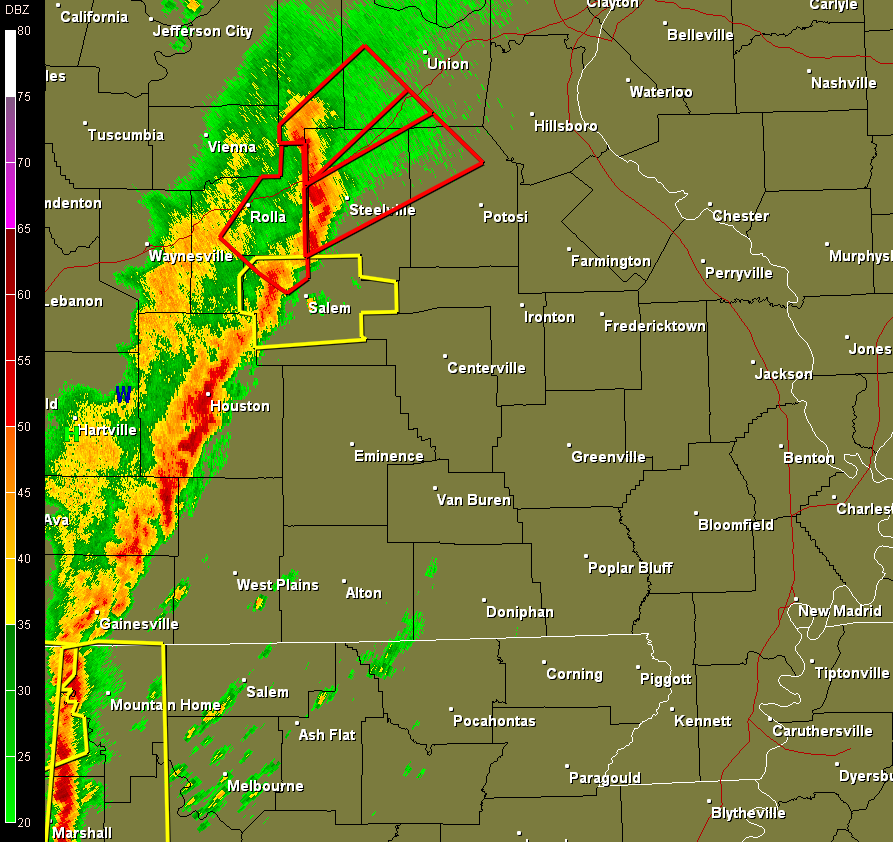
Individual storm cells are tracking northeast but the line of thunderstorms is moving east around 30 mph. This would bring the line in to the western counties of the KFVS viewing area (Reynolds, Ripley and Carter counties) around 12:10pm CT.

The Storm Prediction Center has expanded the "Slight Risk" are further north and now includes the entire KFVS viewing area along with the St. Louis metro area. The main threat still appears to be damaging wind. Secondary is large hail and tornadoes.


I would expect to see a watch of some kind, most likely a Tornado Watch, to be issued for the viewing area sometime in the next 30-40 minutes.

Close really does count

Sorry for the late update. I've been busy today working on things at work, looking over weather data and playing out with a new version of software I use for looking at the atmosphere (Bufkit).

There still appears to be a chance for some severe thunderstorms tomorrow. It will be marginal. As I put on Facebook a little earlier tonight... "Tomorrow's chances for severe thunderstorms is still a little marginal. A few things I would like to see happening in the atmosphere aren't quite there, but its close. With winter thunderstorms sometimes close is good enough. Similar to horse shoes and hand grenades. ;)"

Here is the Day 2 Outlook from the Storm Prediction Center.


The outlook is a little old as it is from their afternoon forecast. The new Day 1 Outlook should be coming out in the next 45 minutes. (Hopefully I will be on my way home at that point and going to bed so you can access from their website.)

They include parts of southeast Missouri and all of northeast Arkansas in their "Slight Risk" area for severe weather. The outlook covers from 7am Friday through 7am Saturday.

The time period I am keying in for the "main show" is between 12pm CT Friday through 9pm CT Friday. The main threat from storms will be damaging wind, however I can't rule out the chance for a tornado or two.

I'm in tomorrow working the afternoon/evening shift so keep it tuned to KFVS12 on your television for the latest. You can also follow me on Twitter (@johndissauer) and you can have severe weather watches and warnings delivered automatically via Twitter by following @kfvsweather or "like" KFVS Weather Alerts on Facebook.

11:50pm UPDATE: The new Day 1 Outlook from the Storm Prediction Center is out.


They have shifted the "Slight Risk" area further southeast. It now includes all of southeast Missouri, western Kentucky, northwest Tennessee, northeast Arkansas and parts of southern Illinois.

SPC is indicating the largest threats from the line of thunderstorms will be damaging wind and large hail. However, isolated tornadoes can't be ruled out.

Wednesday, December 29, 2010

7:00pm Weather Update - Closer look at Friday storms

Winter Turns to Spring

It appears that we have storms coming our way. Not the storms that produce snow, sleet, and ice, but spring-like thunderstorms.

A well advertised cold front will approach southeast Missouri Friday. Ahead and along the front, a line of thunderstorms is forecast to develop.

The Storm Prediction Center has taken notice. They have included parts of southern Missouri (including some counties in southeast Missouri) in their Day 3 Outlook in a "Slight Risk" area.


There aren't a lot of HUGE numbers supporting severe thunderstorms, but in winter we don't need huge numbers. Dew points are forecast to reach the middle and upper 50's. That is plenty of moisture for a bout of winter severe weather.

Typically in the winter the largest threat from thunderstorms is damaging wind and quick spin-up tornadoes. I am thinking the biggest threat will be damaging wind out of round of storms.

It isn't abnormal to be seeing severe thunderstorms in December. Several years ago I did some research on tornadoes in the KFVS viewing area and it showed that December ranks 3rd of all months for tornadoes.

Monday, December 27, 2010

Looking for Snow

I've been looking over some of the long range charts for any chances of snow. It looks like we might have something to keep an eye on, but don't get too excited, it is still several days away.

The National Weather Service's Global Forecast model is hinting at an interesting storm developing Saturday, January 8 that has some potential to produce several inches of snow.

Here is a look at 12z (6am) Saturday, January 8.


The track that the GFS is showing is favorable for big snow for this part of the country.

It is far from a "sure thing" but it will be fun to watch over the coming days if the model keeps this storm intact.

Friday, December 24, 2010

Numbers to Ponder

Here are the bulk of the numbers in for the last 2 runs of the NAM and GFS computer models. You can start to see the models narrowing in on a snowfall solution. There might be an outlier, but you can start to see where is the consensus.

Below is the meteograms for several sites across southeast Missouri and western Kentucky. I have also included Indianapolis, Indiana for friends and family in central Indiana. Before you ask "But John, how much snow will I get...?" These are the only locations available from this type of product in the KFVS viewing area.

Each line represents a different computer model run. Use the legend at the right to determine which line is which model. The 18z runs are the 12pm CT runs and the 0z runs are the 6pm CT runs.

Cape Girardeau, Mo:


Farmington, Mo:


Paducah, Ky:


St. Louis, Mo:


Indianapolis, In:

Thursday, December 23, 2010

Frustration is Setting In

Just as the title says, frustration is setting in with me with regard to the Christmas Eve storm.

GRRRRRRRRR!!!!! Whew. I needed to get that out of my system.

We are 24 to 36 hours from the start and end of the Christmas Eve storm. Oddly, the computer models are having an incredibly difficult time locking in to a solution. When you think they are starting to hone in on something, some flip and some flop.

Tonight new data is currently streaming in. When I compare the forecast surface temperature to the real temperature over the first couple hours of the model run, it is not handling the temperatures well. That doesn't bode well for something that is 24 hours down the road.

I had planned on showing you the new run of the NAM model and what it is indicating for snow totals, but this is the model I am referring to above. Since it isn't handling the temperatures well, it makes it difficult to have any trust in its snow accumulation amounts.

There are several scenarios that could pan out. However the lack of phasing between the northern piece of the storm with the southern piece of energy (as explained in earlier posts) should keep us on the light side.

I still think we will see some snow, but I can also argue the case of us getting flurries to a dusting.

Snow could begin to fall as early as mid-afternoon Friday, but the brunt of the snow should fall starting in the evening. Snow should be over by 7am Saturday.

A note to those of you looking for new careers... If you don't like stress, don't go towards the Meteorology field. ;) haha

I am not sure how much I will be able to update tomorrow as I will be celebrating an early Christmas with my family since I am working Christmas day/evening. If I do post during the day, don't expect anything too in depth. I might be able to give a bit more deeper insights later Christmas Eve night.

11:20pm Update: The new GFS model data is in. It is showing drier air in place over the viewing area, so don't be surprised to see the radar looking like it should be snowing and nothing is hitting the ground. That is because it may be snowing 8,000 feet in the air but is getting sucked up by the dry air.

The column should be moist enough to let it reach the ground around 6:00pm to 7:00pm.

The model is showing 0.10" of liquid to work with. This model is fluffing this up to 1.1" of snow. This fits inside of my 1"-3" range. I do think some places, mainly to the south, will get nothing more than a dusting and 3" may be a little extreme. We shall see....

New NAM Numbers

All of the 12z NAM numbers are in. Remember that so far the NAM has been the most aggressive of all the models with the Christmas Eve storm.

Here is a look at one of the snowfall products available on the internet.


Here is the same product but for central Indiana. (This is for my family and friends back in Indiana.)


So yes, the NAM is showing a lot less precipitation with the storm. This is the going trend amongst all the models. This doesn't mean that it is a sure bet we aren't going to get much, but it isn't looking good if you are wanting lots of snow for Christmas.

It also appears from 3D slices of the atmosphere in the model that there will probably be snow appearing on the radar early Friday but if any does begin to reach the ground it will probably be after 6pm Friday. This is because a wedge of dry air is going to be in place from 5,000 feet to 15,000 feet for much of the day. Above that wedge, there will be moisture but it will be evaporating as it moves in to the drier air. The wedge will thin through the day, but it could take a little while.

I also want to point out the lack of winter storm watches, warnings, and advisories to the west.


There are some advisories in effect across the Dakotas and Iowa, but that is it and they are just advisories. Yet another indication that forecasters are thinking this won't be a big storm.

The Navy Weighs In

Another one of the many computer models I look at for winter storm forecasting is produced by the U.S. Navy. It is called the Navy NOGAPS model.

Here is what last night's 0z Midshipmen's model has to say.

6pm CT Thursday:


You can see the two pieces to the storm coming together. One piece is down in the Four Corners region of the United States. The other piece is over the Dakotas.

6pm CT Friday:


Models have continued the trend of slowing this system down. Notice by 6pm Friday the storm hasn't gotten precipitation to much more east than Springfield, Missouri.

6am CT Saturday:


The model tries to bring the system through southeast Missouri, southern Illinois and parts of western Kentucky overnight Friday in to Saturday morning.

It is pretty easy to see the split pieces of energy. One stays south over Texas. The other is over northern Illinois. As the two tear apart, the moisture tears apart as well. This is well represented by this model, the European model, and the United Kingdom model. If you have followed my blog, you will know that I am a big fan of the European model and I usually lean it's direction when I forecast.

The new morning runs are starting to come in and I hope to be able to look those over and put some thoughts up on the blog. It will depend on how long I am sitting in the Volvo dealership while they are giving my car a check up. haha

I want to hear what YOU want from this storm. Leave your "Christmas Eve Storm Wish List" in the comments section of this blog post.
It is interesting to note that the European forecast agency's computer model and the UKMET (The UK's forecast model) both are going very dry for us with the system. Actually, the European model is close to putting nothing down on the ground for us diego the split flow.

I've said several times in the last couple weeks... I am a big fan of the European forecast model. It isn't as "fashy" in the weather community as some of the other models, but it does the job.

I'm still on the fence. Not too sure what to make of this yet. Other forecasters are having the same problem. You can tell this by the lack of winter storm watches, warnings, and advisories back to the west. It might be another 12-20 hours before things get issued by the NWS.

Wednesday, December 22, 2010

10:45pm Weather Update - Now the Numbers Count

New numbers are streaming in. If you could see my computer screen right now you would see that I have 10 tabs open in my browser looking at the models and comparing them.

I have said for several days that there are two key periods of time I was looking forward to looking at the model data.
  1. When the storm moves on shore the models will be able to get better observations to chew on in the calculations.
  2. When the storm exits the Rocky Mountains.
The storm has moved onshore and is moving across the southwest United States.

The new models tonight are trending the system a little further north. The models are also continuing to split the energy of the storm. There will be a southern branch, where the majority of the moisture will be located and a northern branch.

Lets look at the upper-levels of the atmosphere. Here is the new 0z Global Forecast model from the NWS. This is looking at 500mb or approximately 18,000 feet up in the atmosphere.

Here is the 42 hour (12pm CT Friday) chart.


When looking at the above chart the northern piece of energy is located over Minnesota. The southern piece of energy is over northern Texas.

Here is the 54 hour (12pm CT Saturday) chart.


The northern piece of energy is over Iowa and the southern piece of energy is over northeast Texas.

Right now my feeling is that we could be between the two pieces of energy.

The models are also trending further north with the precipitation. Not only is it trending further north but the amounts are also a bit higher. This would mean potentially more snow for the area.

Lets take a look at a couple of the computer models' snow accumulation maps. Before I show these, I want to remind you that these are numbers straight from a forecast model and may not be what happens. That is why there is a difference between our forecast and the model output.

Here is a look at the 0z RPM model.


The 0z NAM is also taking numbers up dropping anywhere from 0.5" to upwards of a 6" band of snow through the middle of the KFVS viewing area. I, along with several other NWS offices, think the NAM is an outlier.

The new 0z GFS has come in indicating a general 1" to 3" snow over the area.

Here is a look at a couple of the meteograms for a few locations across the KFVS viewing area. The meteograms let you see both the NAM and GFS runs in one screen so you can compare.

Cape Girardeau, Mo:


Farmington, Mo:


Paducah, Ky:


I will be interested to see what the new run of the European forecast agency's computer model shows.

A conversation I have been having with a good friend of mine, who is also the Chief Meteorologist at a television station in Indianapolis, has been dealing with tonight's new data. One thought/concern we have both have is that it has been raining cats and dogs over southern California all day. Could the heavy rains introduce some problems for the models? This could explain the higher precipitation amounts. This is similar to the spring and summer time when we often have convective feedback issues with the models. Or perhaps the models are on to something? Only time will tell.

I wish I could give you better details or insights in to what we are going to see Friday/Saturday, but at this point I don't have them. This is still a very fluid situation.

10:00am Update

The morning run of the computer models are just about in and many of my original questions/concerns remain.

A couple things seem certain.
  • The amount of moisture for the system seems to be decreasing.
  • Models are slowing the timing of the system to Friday evening/early Saturday morning.
  • Models continue to try to split the system taking the brunt of the energy well south of the KFVS viewing area.
Do I think we will see some snow out of this? Yes. How much? It is still too early to have a good feel for it. My initial thought is anywhere from a dusting to as much as 3".

Here is a look at what the 12z RPM model is putting out for snowfall. Again, remember this is just numbers from a computer model. It is NOT my nor the StormTeam's forecast.


The storm is currently moving onshore over the southwest United States and this evening's computer models should have even a better handle on the storm. From now until Friday each run of the models should begin to make the picture a little clearer. Similar to using a camera and having it be out of focus. As you slightly adjust the focus, things begin to get more clear. Each run of the 0z and 12z runs will begin to make focal adjustments.

I'll try to update later tonight.

11:45pm Weather Update - Not Impressed

Most of the new models are in and I'm becoming less impressed with the Christmas Eve storm.

I've looked over four of the new model runs available tonight (NAM, GFS, RPM and the GEM). The majority of them are taking the storm further south much like my trusted European model has done for the last couple of days. This means we would stay all snow for the event. This also means that we would not get as much snow either.

For the snow lovers, here is a look at the model bringing us the most snow, the NAM.


Click on the image to see a larger version.

This is showing snow accumulation from tonight through 6am Saturday morning (Christmas morning). It paints in 1" to 3" of snow for parts of southeast Missouri, western Kentucky, and lesser amounts in southern Illinois.

I need to remind you that the image above is NOT my nor the Heartland StormTeam's snow forecast. It is just an output from an individual computer model run. And as I said above, the model shown above is the model with the most snow. This doesn't mean we will see this much.

The models all seem to agree on slowing the system down, bringing the precipitation in during the second half of Friday or Friday evening versus earlier Friday morning.

I am still on the fence as to what we will see from this system. Do I think we could see some snow from it? Yes. Will it be a lot? I'm not sure yet, but the chances are looking less and less likely.


As mentioned in previous posts, the storm is still out over the Pacific Ocean. (See above) It should begin to move onshore overnight. As it gets over land tomorrow morning, the models should be able to get real data on the storm and then begin to crunch away at the calculations. I wouldn't be surprised to see some changes to the track and behavior of the storm in the models once the new data is ingested.

The other thing we'll have to watch is how the storm appears after it is ejected out of the Rocky Mountains Thursday.

As is always... We'll have to keep an eye on the situation over the next 48 hours to see what we will ultimately get to deal with. Stay tuned...

Monday, December 20, 2010

Evening Weather Update - Still Messy

I am just now getting a chance to look over data for the storm later this week.

Models are in good agreement that we will see a storm move through the mid-section of the country Friday, but that is the extent of the agreement. One of the models, one of my favorites, is splitting the storm and taking the bulk of the system south. It would still bring snow through southeast Missouri, southern Illinois and western Kentucky Friday evening and Saturday.

Other models take the storm right over the above mentioned area. This would bring rain changing over to snow as the system exits.

At this point it is difficult to talk specifics about what we will see. The models should begin to handle this system better within the next 36-48 hours. The storm that is going to bring the "mess" is still located over the Pacific Ocean. Once it is over land the models can get real data and crunch away at the data.

Friday, December 17, 2010

Not Looking Good

It isn't looking good if you are wanting a White Christmas for this year. Long range models slide a small system through early next week, but it will take too much of a northern track to bring us snow.

Perhaps some of you might have a White Christmas if temperatures manage to stay below freezing the remainder of the next week. This would be in locations that already have snow on the ground.

The National Climatic Data Center defines a "White Christmas" as having "a snow depth of at least 1" observed on December 1".

Here is the historical chances of a White Christmas across the country courtesy the National Climatic Data Center.

(Click on the image to see a larger version.)

Wednesday, December 15, 2010

8:50pm Weather Update

I can tell that the heavy mist/drizzle has changed over to light rain as I can hear water running down the gutters.

Here is a look at the radar from the Paducah, Ky radar site at 8:42pm CT.


As I have been saying all along, the key to tonight and tomorrow morning will be the surface temperature. Through the day temperatures were doing what I thought they would. There was a brief "warm-up" in the morning to the mid-30's and then the first wave of moisture started to move through. The moisture didn't come to the ground for the most part. It evaporated and cooled the surrounding air dropping temperatures to 32 degrees or below.

Here is a look at temperatures at 8pm CT.


To read the above graphic, look for the numbers in red. That is the air temperature. The number in green is the dew point. (Click the image to see a larger version.)

Note that temperatures are at or below 32 degrees (freezing) for most of the area with the exception being at Cape Girardeau, Poplar Bluff, and points further south. Some warmer air has worked its way up through southern Missouri, BUT temperatures are barely above freezing. I still think that temperatures will continue to bounce around from 31-33 degrees most of the night. However, across most of southern Illinois (especially north of Vienna, Il) temperatures will stay below freezing.

Forecast models are still indicating that freezing rain will be the main threat from this system. Here is a look at NOAA's Rapid Refresh model at 4am CT Thursday.


This model keeps most of the area as freezing rain (red/orage slashed lines) with light amounts. It does keep the Missouri bootheel and northwest Tennessee as rain.

Just like earlier today, the new model data coming in is trying to bring the higher amounts of ice accumulation to portions of southern Illinois. I continue to feel pretty confident with my 0.1" to 0.2" freezing rain/ice amounts. Lesser amounts would be south of Cape Girardeau in southeast Missouri and south of Vienna, IL in southern Illinois and western Kentucky. The city of Cape Girardeau could see 0.07" to 0.1" of ice accumulation.

The hardest part about this forecast is determining what the temperatures are going to do. This isn't just splitting hairs, it is splitting the hairs of the already split hairs. We are talking about a couple tenths of a degree one way or the other will make all the difference in the world who sees 0.2" of rain and 0.2" of ice. Unfortunately with this system, I can't give definitive answers as to who is going to see what, with the exception of northern southern Illinois where it will be all freezing rain.

I also want to give a mention about snow for people in central and southern Indiana. Looks like my fellow Hoosiers will get a nice little amount. In Indianapolis I think it will range from 1" (northside) to 3" (southside). Areas towards Columbus could see 4"-6" of snow by Thursday night.

12:50pm Weather Update - It's Coming

Just glancing at new data from this morning. Several of the computer models are shifting the precipitation further north from western Kentucky in to southern Illinois. This would mean some of the "higher" amounts of freezing rain would fall across southeast Missouri and southeast Illinois.

Stay tuned for further updates. I'll have more coming up on Heartland News at Noon on KFVS-TV.

It is developing as I type.

Moisture is beginning to break out towards Memphis, Tn this morning. The moisture will take some time to move north in to the KFVS viewing area. Plus it has to overcome some dry air at the surface. This means that a lot of it will evaporate, but the evaporation will lead to evaporative cooling for a while. This is one of many steps that need to take place for this storm to play out the way I've been forecasting.

It is always an extremely nervous time waiting on a storm to develop that in reality isn't anywhere to be seen. It truly is a blind leap of faith with the computer models.

12:20am Weather Update

Just a quick update before I go to bed. The new 0z run of the GFS model is in and is still suggesting freezing rain starts to come in from the southwest around 4:00pm to 6:00pm CT Wednesday. Amounts are pretty much the same. Anywhere from 0.05" to 0.15" inches of ice. Nothing big, but still not good for driving Wednesday night and Thursday morning.

Tuesday, December 14, 2010

9:45pm Weather Update

New numbers are coming in and I am looking over them. It looks like there could be some changes coming to the forecast for the next 36 hours.

So far just the new run of NOAA's NAM model is in. Here is a look at the model data specifically for the Cape Girardeau, Missouri area.


There are several things to look at with the above data.

First, take a look at the precipitation that the model brings through. It starts the precipitation falling around 5pm CT Wednesday and ends the precipitation around 6am CT Thursday.

Second, take a look at temperatures in the air column above us. Warmer air aloft begins to move in starting around noon Wednesday. The gray numbers at the right indicates the height in the sky. (4k = 4,000 feet) The warm air builds in through the afternoon and even drops down to around 1,800 feet by 2am Thursday.

Under the layer of warm air there is cold air with a temperature below 32 degrees F. (The numbers listed on the yellow lines is temperature in Celsius.) With the cold air trapped at the surface, it provides an environment for any moisture to freeze.

Third, take a look at the squiggly red line. The line indicates the temperature at the surface. The gray horizontal lines indicate the air temperature. I have drawn in the 32 degree line with a blue line. Temperatures through the day Wednesday should warm in to the lower 30's, but notice how the temperature holds steady Wednesday afternoon through Thursday morning. When looking closer at the data, it takes our temperature from 31.8 degrees to 32.7 degrees. That would mean temperatures will be flirting with the freezing mark. That is... if this model is correct.

Computer models often have a very difficult time handling the cold air trapped in the lower thousand feet of the atmosphere. It often overdoes how quickly the cold air moves out.

Here is my concern... Will the air temperature at the surface be below freezing? Two years ago when we had the mother of all ice storms, forecast models tried to warm up some of the area to above freezing. All day long the computer alogrithms, that try to determine where the rain/snow line is located on radar, were wrong over western Kentucky. For much of the day we were under the assumption that areas like Murray, Kentucky were seeing rain. It turned out they were seeing rain but the temperature at the surface was around 30 degrees so everything was freezing once it was on the ground.

The models continue to indicate that we are going to see freezing rain initially but it will change over to rain late Wednesday night or early Thursday morning. BUT, ... Will this be the case?

Now I should say again that this is NOT going to a major ice storm for the area.I should now remind you that this is NOT going to be a major ice storm for the area. I've told a few people that I went out over the weekend and bought a small can of deicer, not a gallon of deicer.

I am thinking we will an initially burst of sleet Wednesday afternoon/evening and then it will change over to freezing rain. There could be some very light precipitation falling during the day, but I think the bulk of it will hold off until the evening. There could be a change over to rain but the key will be the air temperature at the surface.

Amounts will generally range from 0.10" to as much as 0.2" of ice. Not everyone will see these amounts. I think areas north and northwest of Cape Girardeau will be less than 0.1" and the heaviest areas will be over western Kentucky and southeast Illinois.

Again, this won't be like the ice storm from two years ago. That was catastrophic. This will be more of an inconvenience, especially for Thursday morning.

What makes this forecast extremely difficult is the fact that this storm hasn't even developed yet. In an essence, forecasters are shooting at a ghost with a blindfold. Are there any uncertainties with this storm? Absolutely! All we have to rely on at this point is computer models. The upper-level energy that will form this storm is just moving onshore over the northwest United States. From this point going forward the computer models will be able to get a better grip on the storm since it will be over land.

Things can still change with this storm and there is a chance this could just be a cold rain. Stay tuned to this blog and keep up to date on the latest forecast on my television station's website, www.kfvs12.com and watch Heartland News on KFVS12. Brian Alworth will be in Wednesday morning on The Breakfast Show from 4:30am to 7:00am. I will be in for Heartland News at Noon. Bob Reeves will be in for Heartland News at 5pm, 6pm, 9pm, and 10pm. If you aren't able to watch the news on your television you can watch it live on your computer by going to the website. You can also watch the news over 3G on your iPhone and some Android mobile devices by downloading the station's free app.

1:00pm Weather Update - Ice Station Zebra

Monday, December 13, 2010

10:00pm Weather Update - "It's as cold as ice"

Looking at the new data coming in for our Wednesday/Thursday weather system.

So far just NOAA's 0z NAM computer model is in. Lets take a look at the atmosphere in a 3-dimensional slice.


I've gone in to the graphic and drawn on a few areas of interest. Mainly the area in the atmosphere where temperatures will be above and below freezing.

Note the warm air that moves in over the cold air at the surface. The warm air will bring moisture up from the south/southwest and run the precipitation over the colder air.

With the depth of the warm/cold air it appears that we are talking about mainly a freezing rain event. This run of the model is also indicating mainly freezing rain (indicated with the red vertical bars). It also tries to change the freezing rain over to rain for a couple hours Thursday morning.

Now don't get too excited or panicked. This is NOT going to be anything like two years ago. The amount of water we are going to be dealing with is probably 10 times less. The NAM is indicating around 0.2" to 0.25" of freezing rain. So far I have seen models zeroing in on the 0.1" to 0.25" range.

The big question for me is timing. The NAM (shown above) and the GFS bring the moisture in around 12:00pm CT Wednesday. The European model has consistently been bringing the moisture in late Wednesday night (after 9pm). I am still siding with the European model on the timing which lingers the freezing precipitation through Thursday morning. We'll have to see how the models handle the storm as we get closer to Wednesday.

None the less... Right now it appears to me that the Thursday morning drive to work or school could be messy and will create some inconveniences. Wednesday's drive home from work or school is still in question due to the onset timing.

One thing I want you to keep in mind with all of the discussion with this storm... At this point the "storm" hasn't yet developed over land. This is just a wave that the models are picking up on and extracting. Once the area of low pressure moves over land in the next 24 hours, the models will be able to bring in soundings that have been able to sample the atmosphere. In other words, there is a chance that a lot could change in the next 24-36 hours.

12:30pm Weather Update

Brr it's cold outside. This morning temperatures dropped down to 6° to 13°. Highs this afternoon will range from around 17° to 27°. If you have snow on the ground it will be colder. No snow, it will be warmer.

It is interesting to look at visible satellite images after a snowfall on sunny days. Here is a look at the visible satellite image from around 11am today.


The white stuff you are seeing is snow. The visible satellite image gives a different perspective on where snow fell. I went in and drew the blue line to roughly indicate where the edge of the "snow pack" is located.

We are still a "go" for the wintry mix coming our way Wednesday/Thursday. I am not able to include the model data imagery at this time because I am not on the right computer to generate the images. (I'll do that later tonight.)

I can tell you that all of the models are on board with bringing in some freezing rain or sleet to the KFVS viewing area Wednesday/Thursday. The timing is still a little in question. The NAM and the GFS models bring it in Wednesday afternoon and keep it going through early evening. The European model has it holding off until late Wednesday night and keeps it through early Thursday morning.

All of the models are consistent on the amount of freezing rain or sleet for the event. They are indicating around 0.10" to 0.15", so we're not talking about the mother of all storms, but it could be enough to make it a little interesting for a few hours.

The storm and it's details are not written in stone yet, the storm hasn't developed in reality yet, and I am sure things will change around some before we get to Wednesday morning so keep up with the forecast on KFVS12 and of course here on New at Dis Hour.

Sunday, December 12, 2010

7:00pm Weather Update - Want some ice with that?

I am looking over the European forecast agency's computer model forecast for Wednesday night/Thursday for the possibility of some frozen stuff (see previous two blog posts).


The European model continues to indicate moisture around the area late Wednesday night and Thursday morning.

I must say that the European model has been doing a terrific job with the last couple weeks of weather systems. The GFS has finally caught up to it for the Wednesday night/Thursday morning ice/sleet stuff. Stay tuned...

3:00pm Weather Update

The snow is just about falling over southern Illinois and western Kentucky. It will be very difficult to get true measurements of the snow due to the gusty winds blowing snow around, but when it is all over we will see the snow amounts ranging from nothing to 4" (in southern Illinois).

Replacing the snow will be cold air. Temperatures will fall to the single digits to the teens. It will be colder where there is snow on the ground over southern Illinois.

Temperatures won't warm up too much Monday afternoon. Take a look at NOAA's Global Forecast model computer run from this morning. (Click the image to see a larger version.)


When looking at the above image, read it from right to left. The red line indicates the air temperature at the surface with the gray horizontal lines. The yellow lines indicates air temperature at different heights of the atmosphere. The blue vertical bars indicates snow. The red vertical bars indicates freezing rain.

Follow the red line and you can see the dip in temperatures tonight and our slight peak tomorrow. The model is indicating highs will be in the lower 20's tomorrow. I think some locations will struggle to get out of the upper teens. It will also be windy.

Lets skip ahead and look towards Wednesday night and Thursday morning. As I alluded to during last night's video update, there is the possibility of some freezing rain in that time period. The European model was hinting at it last night and the GFS was not. This morning's run of the GFS is now on board with a little moisture falling during that time frame.

There are a couple things you have to look at for freezing rain to develop.
  1. You have to have moisture falling in the form of rain. To have rain you have to have temperatures above freezing. Look up a couple thousand feet Wednesday evening. I have pointed out where there is a "bubble" of warm air that moves in. This would allow any moisture that is falling to melt and be rain.
  2. You have to have shallow cold air, below freezing, at the surface. This appears to be the case below 2,500 feet to 1,500 feet. As the rain encounters the colder air it begins to freeze. (I colored in the below freezing layer with blue.
The key is seeing how thick the cold layer is. If it is too thick, you will get sleet. If the below freezing temps stay close to the surface the rain will freeze on contact.

At this point it is looking like it could be freezing rain and/or sleet. The good news is there is not a lot of moisture being spit out by the models. This morning's GFS is suggesting 0.07" of precipitation.

This is still EXTREMELY early to know for sure what is coming. The atmospheric profile could change. 1,000 feet here, 1,000 feet there could change the whole picture. So there is no need to get concerned just yet. This is just something to watch. Stay tuned...

9:00am Weather Update - Radar

Snow is falling across the KFVS viewing area this morning. A look at the radar shows there are two bands of snow moving southeast.


There is likely more snow falling than what is being shown by the radar. Radar typically has a difficult time showing snow.

Do you have snow where you are? If so, let me know how much you have by leaving me a comment in the comment section my blog. Please say where you are located and whether or not you are estimating or have measured how much you have.

Saturday, December 11, 2010

7:00pm Weather Update - Snow Amounts

I've been able to take a look over some of the RPM snow accumulation numbers that I couldn't access at home. I thought I'd share them with you.

Here's a look at the 21z (3pm) run of the RPM for southeast Missouri, southern Illinois, western Kentucky, northwest Tennessee.


Overall, these numbers are pretty close to what I am thinking. Generally speaking, we will probably see 1/2" to 1.5" and a few spots in southern Illinois might see 2". The Cape Girardeau area will likely see around a half inch.

Some spots will see no accumulating snow at all.

Now for those of you living in Indiana... Take a look at the numbers the RPM is spitting out for you.


Keep in mind, this is a running 72 hour total. It appears that there will be a pretty good lake effect snow band setting up somewhere over northwest Indiana. I think some of the inflated numbers you see for Indianapolis and Bloomington includes the lake effect going that far south. It isn't out of the question that could happen for Indianapolis. I think Bloomington is a little far for it to reach.


12:30pm Weather Update

Looking at some of the computer models and it appears they are trying to take the surface low further south. This could mean a little snow further south.

Don't expect the rain we are currently having to change over anytime soon. It's the wrap around precipitation that will bring us the chance for some snow.

Take a look at our hi-resolution model (the same model we show as Precisioncast on the air).

Here is the depiction of pressure, winds, and precipitation at 10pm Saturday.


We will get dry slotted for a little while this afternoon and evening. When the rain moves out shortly from now, don't think the storm has passed and say, "This is all we're going to get?!"

Here is the model at


Here comes the wrap around moisture and in this case, snow. According to this model, the precipitation will start to move back in around 3:00am to 5:00am Sunday.

For the snow lovers, I wouldn't get too excited just yet over this. There will not be a lot of moisture for the cold air to work with. However, what falls should be fluffy and will look neat as it falls.

Here's a look at two computer model snowfall maps. I want to stress that this is just a computer simulation and not an absolute of what will happen.

The 6am run of the National Weather Service NAM model:


The 6am run of the National Weather Service Global Forecast model:


In general, the models are putting down around one inch of snow for most of southern Illinois and parts of western Kentucky with lesser amounts over southeast Missouri and Tennessee.

Something to notice with the two snow output maps above. The Global Forecast model, the GFS, has more of a broader, smoothed out look and the NAM has more little fine details. That is because the NAM is a higher resolution model than the GFS.

I don't have access to specific snow numbers from our hi-resolution RPM model here at home, but I will try to post them when I get in to work today. Ah... yes work. I haven't been there in two weeks. Gotta love vacation and gotta not be a fan of the first day back at work after vacation. haha

See you on the television for Heartland News at 6pm, 9pm, and 10pm.

9:00am Weather Update

The National Weather Service in St. Louis has issued a Winter Weather Advisory for it's forecast area which covers portions of eastern Missouri and western Illinois.


The advisory is in effect from midnight tonight through noon Sunday.

Forecast models are putting down a couple of inches of snow for the St. Louis area. The official NWS forecast is calling for 2" of snow in St. Louis.

Here is a look at a couple of meteograms. This allows you to see what several models are outputting at the same time.

St. Louis:


Farmington, Mo:


Click on the above images to see larger views.

Each line represents a different computer model and a different run of the model. Use the legend at the right of the image to see which color corresponds to which model. The run of the model is designated by the time stamp preceding the model name. The time is listed in UTC.

Temperatures are still expected to fall starting later tonight. Here is a look at the temperature forecast by the models for Cape Girardeau.


Bundle up!

Friday, December 10, 2010

Weekend Storm Update

There has been a lot of talk about a possible storm for this weekend. It still appears we are going to see a storm move through Saturday, but it might not be as much of a snow machine as it will be a rain, cold air, and wind machine.

The computer models are starting (finally) to come in to alignment for the storm. For the last week the European model has kept the storm to the north and the GFS has kept the storm further south. A more southerly track would mean snow for the KFVS viewing area. A more northerly track would mean the storm would be warmer and be rain. The winner appears to be the European model.

Here is the European model's depiction of 12pm CT Saturday.


It takes the low through Iowa and spins it up over Wisconsin. A cold front will be sweeping through southwest/northeast Missouri. Along the cold front showers and thunderstorms will break out.

Cold air begins to sweep in behind the front. If there is any moisture left over when the cold air comes in we could see a little changeover, but I don't think there will be much to talk about. Even as the upper low swings through on Sunday, I think the small amount of moisture with the system will stay north of southeast Missouri, southern Illinois, and western Kentucky. At best we could see some flurries during the day Sunday.

I think it will be much of the same for those in central and southern Indiana. Rain will begin to move in Saturday night. Cold air will come in on the backside of the storm. You could see a little bit of snow on the backside of the system as the upper-level low swings through. I wouldn't be surprised if there is 0.5" to 1.5" of snow on the ground by Sunday night. One of our hi-resolution models is trying to hint at some lake effect snow bands making their way as far south as Muncie by Sunday afternoon, but we'll see if that really pans out.

The bigger story for Sunday will be the cold air and winds. It will be interesting to watch the New England Patriots vs Chicago Bears football game Sunday afternoon in Chicago (which you can watch on KFVS12). Winds will be gusting over 40 mph in Chicago that day.

So is this a big winter storm? The way it looks right now, not so much. Could something change? Yes. The models could do a big turn as the storm actually develops over land. Stay tuned...

Long range computer models are still hinting at a pretty potent storm developing around December 22-24 that will sweep through the Midwest and likely cause some travel issues for Christmas. It is way to early to tell if we are talking rain or snow yet.

I'm back from my trip to Florida and getting ready to head back to work tomorrow after some time away.

Wednesday, December 8, 2010

Just looking over the latest weather data before turning in for the night. It still looks like we could have a winter storm to deal with for the weekend.

There is still some disagreement in the position of the storm Friday/Saturday/Sunday, however there is some indications there could be frozen precipitation (snow, freezing rain, sleet, etc) falling across south central Missouri up through south central Illinois to Indiana.

It is way to early to talk about exact placement and amounts. I will hopefully have more tomorrow night.

Also look like we could have a White Christmas.

Stay tuned...

Tuesday, December 7, 2010

Looking at weather data this morning and it looks like we could be in for a close call this weekend. A close call for what? Possible rain, sleet, freezing rain, or snow.

The NWS' Global Forecast Model is taking the storm on a southern track and the European Forecast Agency's forecast model takes it on a northern (warmer) track.

I'm back in town late tomorrow and will try to put some more detailed information up on the blog when I get back.

Friday, December 3, 2010

Just tools glance over a couple computer models' 0z runs. Nothing too exciting showing up in them. It does appear as though we will see another shot or two of colder air coming down or the eastern half of the U.S. by December 12.

Thursday, December 2, 2010

I am not sure how this will work as I am updating my blog via text message. I just went through and took a look at tonight's (Wed) computer model runs and everything is indicating no storm for Dec 7-9. Sorry.